This looks fun:
WGN fleshes out the forecast's bones:
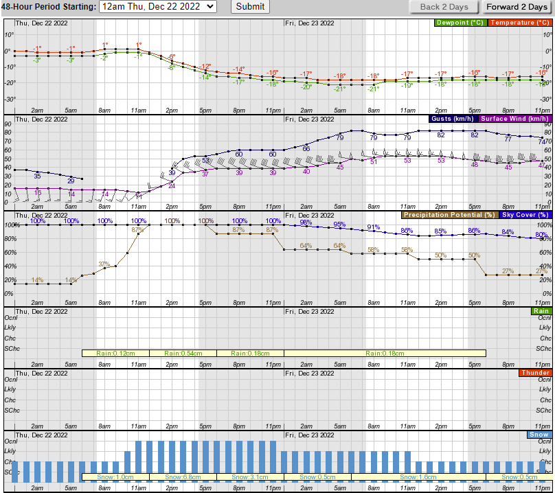
- Snow develops Thursday – beginning in far western sections (west of Interstate-39) during the morning and spreading east with deteriorating conditions across the area by early-mid afternoon
- Blizzard conditions possible, particularly late Thursday night through Friday afternoon (heavy blinding blowing snow with visibility under a quarter mile or less for at least 3 consecutive hours). Very difficult and dangerous travel conditions.
- Wind gusts to 90 km/h may cause power outages. Winds shifting to the W/NW area-wide by Thursday afternoon with initial gusts 50-60 km/h, peak gusts 90 km/h+ later Thursday night and early Friday.
- Dangerous life threatening wind chills, falling temps Thursday afternoon. Sub-zero [Fahrenheit] wind chills possible by late afternoon and early evening Thursday. Increasing winds and falling temps could eventually result in wind chills of -28°C to -37°C by Friday/Friday night with wind chills well below -18°C continuing through the weekend.
So, I had planned to work downtown tomorrow, which will still happen, just for a much shorter interval. And I had planned to let Cassie hang out with her friends at day camp all day, because my darling middle-aged dog has the energy of a whippet puppy if she doesn't get many hours of play a week.
And, as I mentioned yesterday, I also had planned to review a couple of breweries Friday afternoon. That will also have to wait.
As long as I don't lose electricity, Cassie and I will ride it out at home Friday. And if the power goes out, at least I have a gas fireplace and a warm dog.