Note: The DOMA and Prop 8 decisions just came out during the phone meeting that interrupted this entry. I'm sure I'll have something to say about SCOTUS in a few hours. Right now, I have to take advantage of the letup in rain and get to the office.
We now return you to your regularly-scheduled blog entry, already in progress:
The monsoon-like rains stalled over the Chicago area today, which will push us past having more precipitation in six months (662 mm as of 7am, with the rain still coming down) than we had all last year (684 mm), isn't the only bit of weather this week enhanced by anthropogenic climate change. Yesterday it was hotter in Alaska than it's been in Chicago since last summer:
Alaskans dealing with unusual heat; Fairbanks' 33.3°C Tuesday high exceeds Chicago’s 2013 peak to-date of 32.7°C to date.
It was snow and an abnormally chilly late spring temp regime which headlined Alaska weather only a little over a month ago. Since then, an extraordinarily rapid transition to record heat has followed—a warm-up which has generated some of the state's warmest temperatures on the books.
The 33.3°C high recorded Tuesday at Fairbanks is warmer than any daytime high recorded yet this year in Chicago. And 90s [Fahrenheit]—in some cases mid-90s [Fahrenheit]—were common in Interior Alaska Tuesday with some 90-degree temps recorded in Canada’s adjacent Yukon Territory as well.
In fact, the heat in central Alaska may accelerate climate change, since melting tundra releases methane gas into the atmosphere. Fun times, fun times.
We've got a bit of rain in Chicago this morning:
UPDATE: 7:00 am
Arlington Heights 93 mm
Mundelein 65 mm of rain
Wheeling Chicago Executive airport 107 mm between 4-7am
Lake Zurich 135 mm
McHenry 134 mm- Most of it falling since 3am
Crystal Lake 24 hour rainfall 114 mm
The rain has shut down area transportation:
Flooding has closed the Edens Expressway at Pratt Avenue this morning and has stopped at least three trains on Metra's Union Pacific Northwest Line.
The expressway was closed around 7 a.m., according to the Illinois State Police. Officers were diverting northbound traffic at Peterson Avenue and southbound traffic at Touhy Avenue.
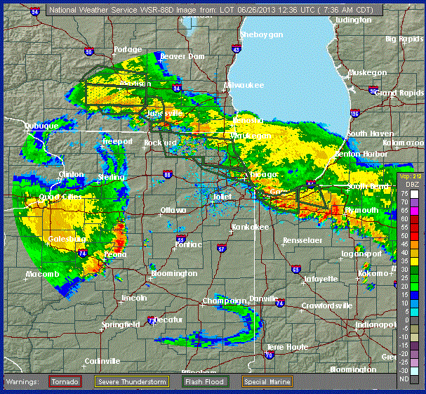
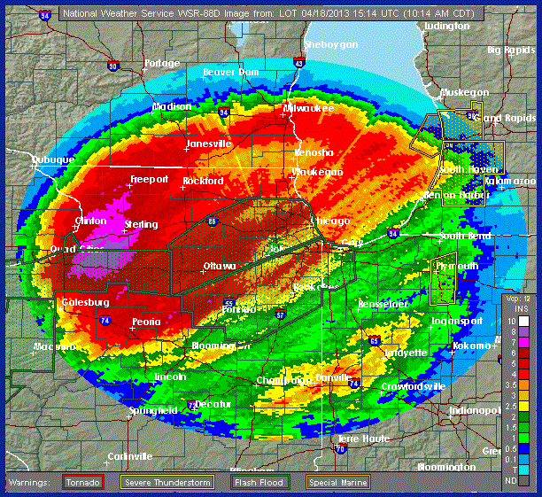
Here's the one-hour rainfall total from the National Weather Service:
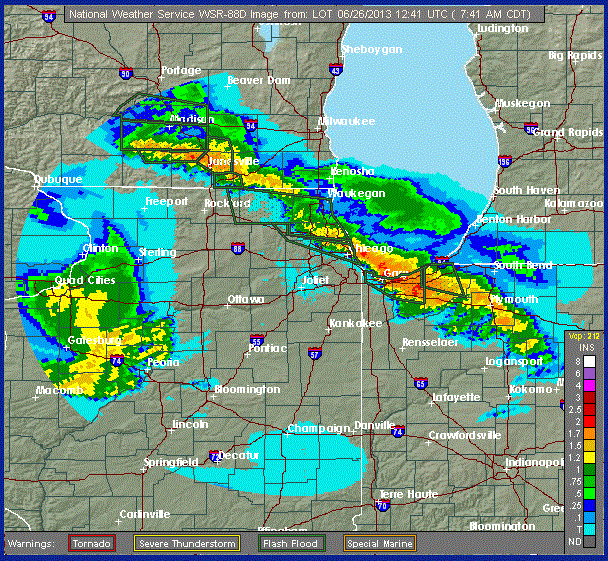
And the current image, showing a line of storms stalled across the region:
I'm debating going into the office...
The twister—as much as a 4200-meter-wide monster can twist—that hit Oklahoma last week broke all kinds of records:
In the rare category of EF5 tornadoes, the one on Friday in the El Reno area was “super rare,” a National Weather Service meteorologist said Tuesday.
The Weather Service updated its estimate Tuesday of the tornado that struck El Reno Friday, determining it was an EF5, the strongest classification for a twister. It was a record 4.2 km wide and tracked across 26 km.
During Friday's storm, the University of Oklahoma RaXPol — a rapid-scan, polarimetric mobile Doppler radar — measured winds greater than 475 km/h at several times and locations within 150 m of the ground along the south side of subvortices on the south side of the tornado.
Fortunately (there's an understatement), the tornado struck a rural area some distance from Oklahoma City, and no one got seriously hurt
But...wow. That's one hell of a storm.
National Public Radio has created an interactive map that uses Google Maps and new satellite images Google obtained yesterday to show 10-meter images of the Oklahoma tornado's destruction:
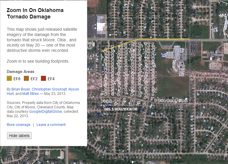
This may be the best, most timely use of geographic information in a news presentation I've ever seen.
The images are stunning. I can only imagine what life must be like in Moore right now—and with the NPR app, it's a lot easier to understand.
It's 26°C and sunny in Chicago right now, so I'm going for yet another walk. Regular posting to resume later today or tomorrow.
Less than two weeks ago, southern Minnesota had 25 cm of snow on the ground. Yesterday, the region hit 40°C following the biggest two-day temperature swing in decades:
Even more dramatic were the stunning weather changes which occurred to Chicago's west Tuesday. Soaring temperatures smashed records from Nebraska into western Iowa, Minnesota and western Wisconsin—areas which less than 2 weeks earlier had been crippled by a record-breaking foot or more of late-season snow.
Albert Lea, Minnesota recorded a 38°C high Tuesday. Only 12 days earlier that city had been buried under a 250 mm accumulation of snow.
Iowa's state climatologist Harry Hillaker reported in a special weather statement out of the National Weather Service Forecast Office in Des Moines Tuesday that 38°C or higher temperatures have occurred in the month of May on only 11 occasions since official weather records began in the state in 1873. Even rarer have been 38°C readings two weeks after a major snowstorm. Hillaker reports this has happened only a few times over that period.
Here in Chicago, O'Hare hit 33°C and Midway hit 32°C, while at Inner Drive Technology World Headquarters—800 m from Lake Michigan—the temperature hovered around 21°C until the sun went down. Without the sun heating the city, the lake breeze stopped, and temperatures rose. Sitting at Wrigley Field last night, I had my sweater on in the first two innings and was down to a T-shirt by the 6th.
Today's forecast calls for rapidly dropping temperatures bottoming out around 14°C by 4pm.
Welcome to 400 ppm CO2, folks. With more energy in the atmosphere, continental climates like the Midwest U.S. will have these violent temperature changes pretty normally from now on.
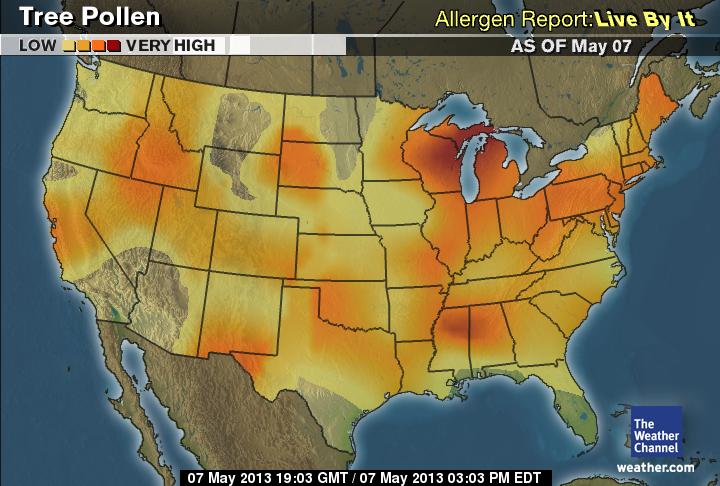
Pollen levels in Chicago have exploded in the past week:
The area’s pollen values surged Tuesday to the highest levels of the year, the latest development in a allergy season which has brought misery to many across the Chicago area. Dr. Joseph Leija, allergist at Loyola Gottlieb Memorial Hospital and provider of this area’s pollen counts, lamented in his daily report that the slow pace of spring warming has combined with the season’s huge rain tallies to bring high tree counts at the same time high grass and weed levels are present. The result, says Dr. Leija, has been to make allergy sufferers miserable despite the lovely weather of late. Swollen and itchy eyes were among the reasons many patients visited his office as well as the need for medication adjustments
Tree, grass and weed pollen were ALL reported as “high” Tuesday. Tree pollen reached 1,000 grains per cubic yard—just 500 below the “alert level” of 1,500.
This is just tree pollen; the mold, grass, and ragweed maps have pretty colors over Illinois also:
I've been sneezing and coughing for three days now. I'm really looking forward to the plants finishing up their orgy of...well, orgies.
Did I mention cold and wet? Yeah, it's wet all right:
Tuesday marked April 2013's 11th day of measurable rain. The day's 15.5 mm rain accumulation was enough to put this month's 215 mm tally (late Tuesday night, with rains still falling) into the record books as the wettest April to occur over Chicago's 143-year observational record.
The previous record for most April precipitation here—212 mm—was retired after a 66 year run dating back to 1947.
The new 215 mm monthly total is more than 9 times (939%) the amount of rain which had fallen during April's opening 23 days a year ago (23 mm) and 2.5 times the full month's 86 mm "normal" total.
Add to that, we're running 2°C below normal, and we've seen 41% of our possible sunshine (normal for April is 52%).
The rain has helped Lake Michigan water levels, but not as much as one would expect.
This weekend they're predicting 21°C and sunny, finally. We'll see.
We had a lovely weekend in Chicago, and today the sun is still out. Not like last week, which drenched the state:
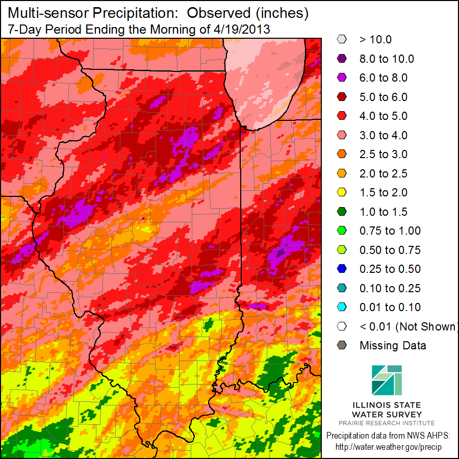
Northern and central Illinois saw widespread heavy rains on April 18-19, 2013. As a result, widespread flooding occurred first at the local level and then along major rivers by the weekend. Last year we had the drought; this year we have what I’m calling the “anti-drought”.
Below is the multi-sensor precipitation map for the 7-day period ending April 19, 2013. This map is based on radar-estimated precipitation and calibrated using available raingauges. Some of the heaviest rains fell north of a line between Quincy and Kankakee. Areas in purple reported between 150 and 200 mm, while the areas in the two shades of red were between 100 and 150 mm. Areas to the south of Interstate 70 escaped the heavier rains.
So, yeah. Damp.
Oh, and the Cubs are now 5-12, going into a 3-day series against first-place Cincinnati. So, yeah.
For five whole days of the past seven, I saw sunlight. Not a little; I saw tons of it. There were rumors of clouds, but mostly, just sunlight.
Since I returned home Tuesday night we've not had any. Instead, we've had this:
Storm totals in just the last 14 hours have gotten up to 125 mm in places, flooding highways and making life a wet hell:
The first expressway closures occurred around 5 a.m. The Edens Expressway was closed between Foster and Touhy avenues and between Winnetka and Willow roads, and the Eisenhower Expressway was shut down in both directions between North Avenue and York Road and westbound at Mannheim Road, Illinois State Police said. The southbound Kennedy Expressway was closed at Addison Street, police said.
As of 9:30 a.m., the Kennedy was open in both directions, though some standing water remained. The Edens was closed in both directions between Lake Street and Dundee Road in the north suburbs, and the northbound Edens was closed at Montrose; the westbound ramp from Interstate 290 to Interstate 88 was shut down, westbound 290 was closed at St. Charles Road, and eastbound 290 was closed at York Road; two lanes were closed on the Bishop Ford northbound between 130th Street and the Beaubien Woods.
Travel times during the morning rush ran at least two hours or longer in some areas.
For my part, both last night and this morning I misjudged approaching squall lines and got a bit damp. Parker, for his part, missed them both completely.
It seems the rain has moved off to the east now as a warm front pushes up through the area. (It's 10°C at O'Hare but 19°C in Valparaiso, 70 km southeast.) The warm front will depart the area later today, just to keep variety going, dragging more rain and cold back through overnight.
We may get drier, warmer weather someday. Someday.