This weekend's weather forecast in Chicago predicts the coolest weekend since May 12, 14 weeks ago. Through Sunday temperatures should be 3°C below normal (days in the low 20s, lows in the low teens), with sunny skies and cool northeast breezes. September, in other words.
The Tribune points out:
Only 6 of past 142 years have produced Aug. 18 overnight lows cooler than those expected by Saturday morning.
Not only will daytime readings be cooler than typical for mid August, nighttime lows will be cooler than normal as well, particularly in areas farthest from the city and Lake Michigan---both of which temper early season cool spells by adding heat.
Friday night/Saturday morning's predicted 12°C low would become Chicago's chilliest minimum temperature in over two months and would qualify as one of the six coolest early season readings for the date since 1871.
It will warm up mid-week, though not to the temperatures we suffered through in the warmest July in history last month. I've got the windows open, and I'll probably be able to keep them open until Wednesday.
Parker likes having the windows open as well, but he's not used to hearing the neighbors—in particular, the neighbors' dogs. I hope he figures it out, because the random, single woofs at 2am are really aggravating.
The WGN Weather Blog reported this weekend that the El Niño-Southern Oscillation has turned warm in the past couple of months, and is getting warmer. The Climate Prediction Center started noticing in July:
Nearly all of the dynamical models favor the onset of El Niño beginning in July - September 2012 (Fig. 6). As in previous months, several statistical models predict ENSO-neutral conditions through the remainder of the year, but the average statistical forecast of Niño-3.4 increased compared to last month. Supported by model forecasts and the continued warmth across the Pacific Ocean, there is increased confidence for a weak-to-moderate El Niño during the Northern Hemisphere fall and winter 2012-13. El Niño conditions are likely to develop during August or September 2012 (see CPC/IRI consensus forecast).
Normally, warm winters lead to warm summers in Chicago, with the pattern resetting in late Autumn. That is, even this record-breaking summer could be followed by a bone-chilling winter. But El Niño years tend to give Chicago warm, dry winters. I'm all for mild winters—except that mild winters tend to cause warm summers, which I am not in favor of.
At least autumn should be lovely here.
I got back home last night after spending a week in cool, California coastal weather. Apparently I brought some of it with me:
The return of sunshine this weekend is to send temperatures higher. It's a change which will be noticed given the fact it follows the first back to back below-normal days in over 6 weeks. Saturday's predicted 26°C high represents a 3°C increase from Friday's 24°C reading—and Sunday's 29°C tacks another 2°C on the day's peak reading.
But, while warm and eminently comfortable, the readings predicted Saturday and Sunday are the lowest of any weekend since June 2-3—10 weeks ago!
Yes, we're having the coolest weather in 10 weeks. I opened my windows when I got home, and I will likely keep them open through tomorrow afternoon, which would be the first time since early June I've kept them open for a full day.
It will get warmer this week, unfortunately, but after the warmest July in U.S. history we have to expect a warm August, September, and October.
Today, though, I'm really enjoying the weather.
The 30-Park Geas took me to Petco Park last night, where the 4th-place Padres beat the 4th-place Cubs:
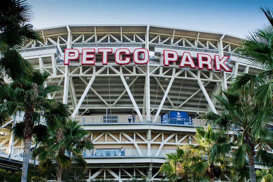
I thought the park was OK. Like some of the other 21st-century parks, it seemed to lack character. It felt more corporate than, say, Camden Yards or even AT&T Park. The fans seemed to agree, as only about 27,000 showed up (out of a capacity of over 42,000.
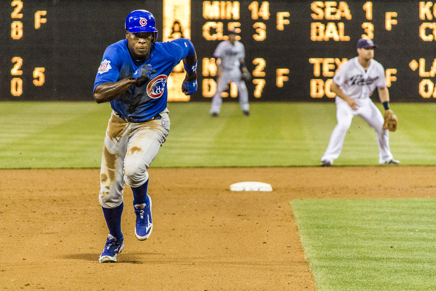
But the lack of demand for seats let me get an 8th-row field box for under $80. And that, in turn, let me get photos like this one of Alfonso Soriano stealing 3rd:
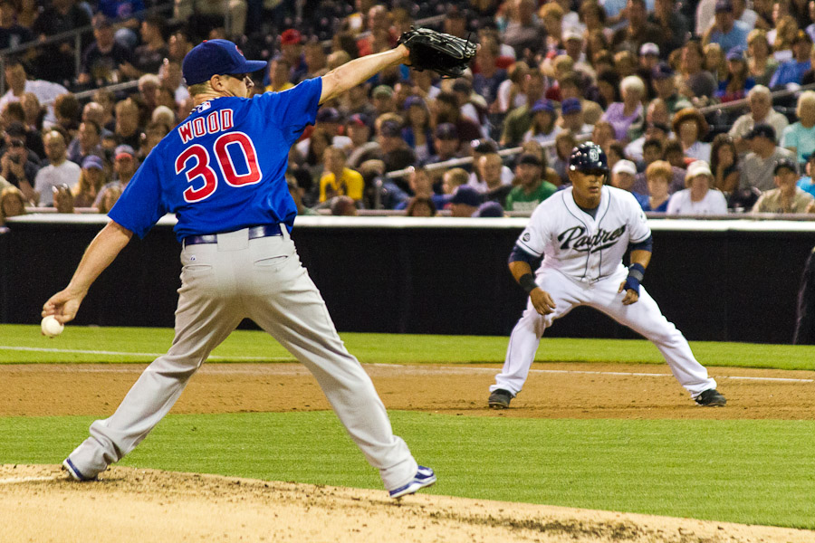
Or this one of Travis Wood pitching:
I'm now up the coast, at my folks' house. More photos tomorrow.
It's not just Chicago; the Illinois State Climatologist has pronounced this year hotter than hell:
This year so far is the warmest and third driest on record. The statewide average temperature for January-July 2012 was 56.9 degrees, 5.5 degrees above normal. The statewide average precipitation for January-July was 357 mm, 249 mm below normal or 59 percent of normal.
Statewide Average Temperature Rankings for January-July
- 2012: 13.8°C
- 1921: 13.4°C
- 1987: 12.3°C
- 1998: 12.2°C
- 2006: 12.1°C
Statewide Average Precipitation Rankings for January-July
- 1936: 310 mm
- 1934: 344 mm
- 2012: 357 mm
- 1988: 371 mm
- 1914: 386 mm
That said, I'm sitting outside with my laptop on a lovely, clear 26°C night. The really awful heat returns tomorrow, though...
The month ended with Chicago Midway reporting its warmest July ever, while our official O'Hare station had the second-hottest ever:
Of all the summers on the books over Chicago's official observational record dating back to 1871, only the 1921 season managed a temperature higher than the 25.3°C reading on the books to date this year. That makes this the warmest opening two-thirds of a meteorological summer season here in 91 years.
The bleak rainfall situation continues across the area as this year's drought worsens. At 116 mm, this summer's rain tally ranks 23rd driest of the 142 years to which we can compare it.
And it's not over; the Climate Prediction Center published this map yesterday:
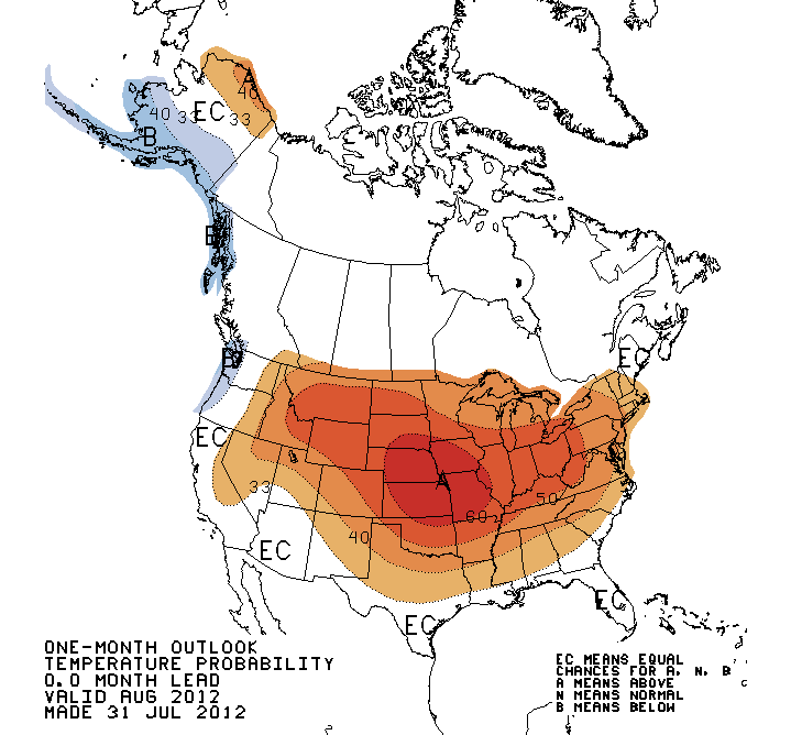
The good news is, we'll probably have a warm autumn, too...
Chicago's average temperature this July will probably wind up at 27.2°C, making it the third-warmest in history behind 27.3°C 1921 and 27.4°C 1955. (Normal is 23.3°C.)
Along with the near-record heat we've had more 32°C days so far than ever before. And it's not over:
Never before, over the term of Chicago's 142 year observational record, have so many 90s accumulated at such an early date.
July alone produced 18 days at or above 90---far beyond the seven considered normal, yet just shy of the 19 days of 90s recorded in 1955 and 1987—both record highs for the month.
History tells us we've likely NOT seen the last of the hot air. An estimated 35 percent (more than a third) of Chicago's remaining 90+degree temperatures have typically occurred from this date forward.
At least today and tomorrow should be cooler, 27°C today and 28°C tomorrow, before going back into the red zone on Thursday.
Roll on October...
...because most of our maize corn is dying too:
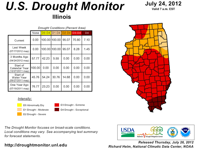
The latest U.S. Drought Monitor has expanded D3 “extreme” drought across Illinois. It went from 8 percent of the state last week to 71 percent this week. This major shift was based on a number of short-term drought indicators based on rainfall, streamflow, and temperature, as well as from widespread reports of significant crop and pasture losses.
Earlier this week, the USDA NASS reported that 66 percent of the corn crop, 49 percent of the soybean crop, and 91 percent of pasture was rated poor to very poor. Topsoil was rated at 91 percent poor to very poor and subsoil was rated 97 percent poor to very poor.
The hottest July ever in Chicago averaged 27.4°C; so far this month has averaged 27.8°C, though today and Saturday are forecast to be about normal.
Food prices, electricity expenses, health-care costs: all are higher this month than one would expect for July. Welcome to the 21st Century, where the weather is as if everyone has moved 800 km south.
Chicago today looks set to get up to 39°C, part of an emerging pattern of worsening heat waves in the region.
The holy terror this summer, however, is 2,000 km to the northeast. Greenland has experienced unprecedented thawing this month:
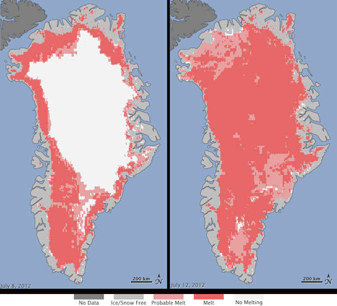
The set of images released by NASA on Tuesday show a rapid thaw between 8 July and 12 July. Within that four-day period, measurements from three satellites showed a swift expansion of the area of melting ice, from about 40% of the ice sheet surface to 97%.
About half of Greenland's surface ice sheet melts during a typical summer, but [Jay Zwally, a glaciologist at NASA's Goddard Space Flight Center] said he and other scientists had been recording an acceleration of that melting process over the last few decades. This year his team had to rebuild their camp, at Swiss Station, when the snow and ice supports melted.
He said he was most surprised to see indications in the images of melting even around the area of Summit Station, which is about two miles above sea level.
It was the second unusual event in Greenland in a matter of days, after an iceberg the size of Manhattan broke off from the Petermann Glacier. But the rapid melt was viewed as more serious.
Greenland's ice sheet accounts for possibly 25% of the world's fresh water. A massive release of that water into the North Atlantic would not only raise sea levels worldwide, but also could distrupt thermohaline circulation, which in turn would make northern Europe's weather more like Canada's.
Of course, we'll all forget this in the winter, and react with surprise and alarm in a year or two when we have another record-breaking summer. Time to adapt.
I hung out with some very old friends yesterday, and throughout our barbecue we checked up on the Cubs. By the time we went inside, it was top of the 7th, no score.
Then this happened:
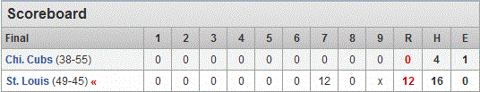
Rafael Furcal's go-ahead single in the seventh turned out to be a mere appetizer as the Cardinals also matched an 86-year-old franchise record for runs in an inning. St. Louis totaled 10 hits with multiple hits by three players including pinch-hitter Allen Craig, who doubled twice with an RBI.
The Cardinals totaled nine doubles for the first time in franchise history since setting a modern major league record with 13 doubles on July 12, 1931, against the Cubs.
Cubs starter Matt Garza was taken out after three scoreless innings with cramping in his right triceps, an injury that wasn't obvious and prompted speculation that he had been traded. The Cubs added a bit of intrigue, waiting until the bottom of the sixth to announce the injury and the fact X-rays -- as a precaution for possible elbow issues -- were negative.
Germano got unlimited warmups in the fourth, an indication he was entering because of an injury or ejection, although the rule book also allows for an unspecified sudden emergency. Germano allowed a run in three-plus innings before the roof caved in on the Cubs, who allowed 12 runs in an inning for the first time since July 30, 2010, at Colorado.
Twelve runs. One half of an inning. Twelve runs. Only the presence of one friend's 11-year-old daughter kept us from expressing our true feelings about what we were watching unfold before us.
After 35 years of watching them do things like that, I'm starting to think of moving on.