The snow has fallen for about 20 hours straight. We're still enjoying it, mostly, because it's Sunday morning and not everyone has put pants on yet. (Parker insists I put pants on every morning by 8. He still hasn't learned how to put on his own leash.)
So it's still kind of pretty:
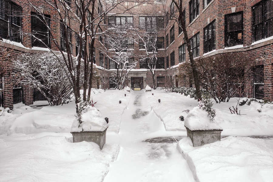
As I sit in my (eerily quiet) apartment Inner Drive Technology World Headquarters, watching the snow swirling around out there, I am very glad I replaced my windows and have a washer and dryer inside. I'm not pleased that my favorite boots have started to leak. And I'm not looking forward to tomorrow's weather.
We proudly welcome the oncoming polar vortex tomorrow evening:
The polar vortex is an area of cold low pressure that typically circulates around the Arctic during the winter, spreading tentacles of cold southward into Europe, Asia, and North America at times. Except this time, it’s not a small section of the vortex, but what one forecaster, Ryan Maue of WeatherBELL Analytics, called “more like the whole enchilada” [that's visiting the eastern U.S.]
The Chicago Weather Center predicts starting Sunday night “a non-stop 60 hour stretch of temperatures which fail to break above 0-degrees” – the longest such period of the past 18 years.
The core of the cold reaches the Ohio Valley and East Coast Monday night into Tuesday, when temperatures drop 20 to 40+ degrees below normal.
The cold air will slowly begin retreating Wednesday.
Here are the temperature, wind, and precipitation probability graphs for the next 48 hours (click for full size):
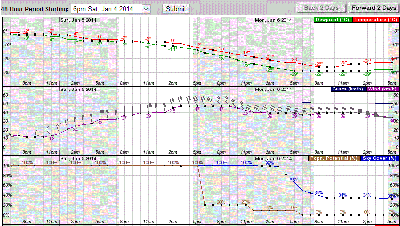
The next 48 hours look almost as bleak, with the temperature line staying below -18°C until around midnight Wednesday. Strangely enough, it just keeps going up from there, hitting the freezing mark on Friday morning.
So: two days of the coldest air anyone has experienced in Chicago since the 66 hour stretch we had in February 1996.
Can't wait.
At least, it's sunny and warm in my office. Outside it's sunny and -18°C. I experienced what may be characterized as a "brisk" walk from the bus this morning.
This, believe it or not, will lead to a brief respite from the winter we didn't really expect. The Tribune reports this morning that the 50 hours of snowfall we had earlier this week put down more snow than any other storm since February 2011. It gets better:
There’s plenty of snow to blow around. The 620 mm on the books to date for the 2013-14 Chicago snow season is the heaviest tally this early in 13 years. What’s more, the 50 hours of “on and off” snowfall, which began Tuesday (New Year’s Eve) afternoon, had by late Thursday produced the biggest accumulation of snow here since the February Ground Hog’s Day Blizzard in 2011.
Midway Airport was home to a 312 mm storm total the past 3 days while O’Hare checked in with 277 mm. Amounts were even more impressive north and west of the city. There, as much as 450 mm fell at Arlington Heights and Gurnee....
Oh, but wait for it:
Bitterly cold air is to come crashing southward into the Lower 48 over the weekend, producing wind chills as low as -60°C in northern Minnesota by Sunday morning. That level of chill is occurring as a brutally cold air mass proceeds south from Canada, breaking a host of temp record records on the way, and producing a non-stop 60 hour stretch of temperatures which fail to break above 0-degrees. That would be the longest sub-zero [Fahrenheit] period of the past 18 years.
Monday's forecast calls for a high around -22°C and a low around -27°C outside the city and -24°C overnight.
For some reason, the Climate Prediction Center believes we'll have above-normal temperatures shortly after that. One can dream...
My walk to the bus this morning, through a park path that I forgot they don't shovel:

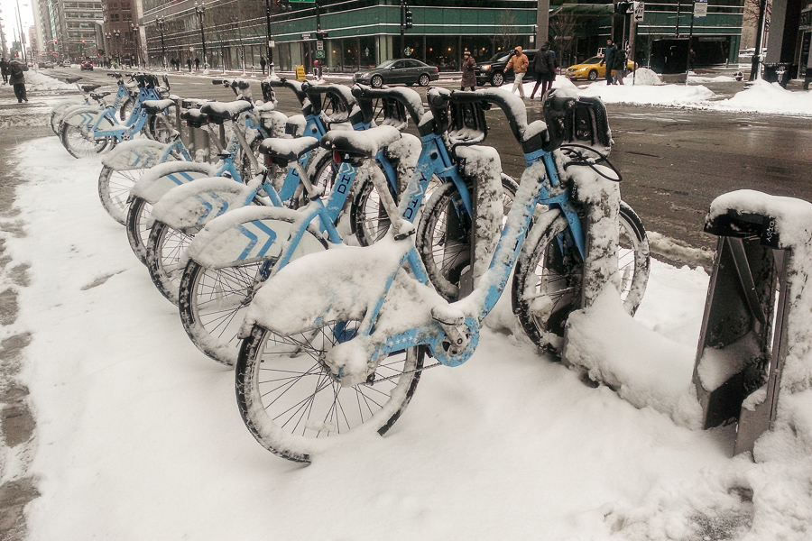
I could have taken a Divvy bike but...well, for some reason they're closed today:
The good news is, it's stopped snowing for now. The bad news is, we're heading down to -17°C tonight.
I texted some friends in Atlanta and Houston with the top photo. For some reason they don't want to visit Chicago just now.
Here's the Tribune's weather infographic for today:
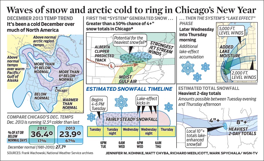
The warmer-than-normal temperature formerly over Alaska has now swung around into the arctic, dragged by a persistent high pressure over the pole. That's pushing cold air down into the Prairie Provinces and the upper Midwest. Meanwhile, warmer-than-normal temperatures over the south-eastern U.S. and Caribbean is dragging moisture right over the lower Midwest.
Consequence: it's -12°C here right now, and in 36 hours we'll have 250 mm of snow.
We're getting a real winter this year. W00t. :/
Two popular Evanston restaurants, Pine Yard and Taco Diablo, burned to the ground this morning:
Fire crews from several neighboring communities -- including Morton Grove, Wilmette and Skokie -- were called to the scene to assist Evanston firefighters in battling the blaze.
The fire apparently broke out sometime before 3 a.m. and fire crews were still fully engaged in battling the blaze nearly three hours later.
The bike shop next door suffered water and smoke damage. Twelve pets at the Bramer Animal Hospital (where Parker went to the vet for his first year and a half) got evacuated.
Pine Yard was Evanston's go-to Chinese restaurant. Taco Diablo also had a large following.
I'm a few minutes from leaving my folks' house, looking at the weather forecast for Chicago. We may set a new record:
The unseasonable late-season 10°C “warmth” which greets Chicagoans Saturday has swept into the area from southern Missouri over the past 24 hours. It’s stay is to be one of limited duration.
A bitter southward plunge of frigid arctic air begins a downward temp spiral here Sunday which is to culminate in colder-than- -18°C Monday morning lows and single digits daytime highs—the coldest readings to occur here in the nearly five years since January 16, 2009 when the high temp rose no higher than -15°C
A temperature drop of that magnitude would become the 2nd greatest three-day late December temp dive on the books over the past 143 years. The only 3-day temperature drop more significant than this is the 34°C drop—from 15°C to -19°C back in January of 2009.
This is why I've just booked a trip to somewhere warm for February.
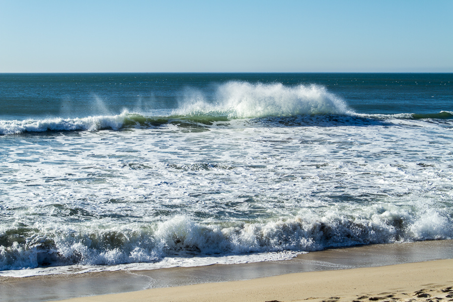
Check these out:
More later, including, I expect, more photos of the ocean. Why? Because ocean.
Update: Speaking of the ocean, via George Takei's Facebook feed comes this gem. Just read the product reviews.
Back in October, Chicago O'Hare International Airport opened its fourth east-west runway and promptly switched most operations to east-west from the diagonal pattern they'd used before. Chicago Tribune transportation writer Jon Hilkevich, a private pilot, explains the implications:
Today taxi times to the gate are generally longer than they were several months ago because of a longer route that takes arrivals an extra mile or more around the airfield. The purpose is to have the planes taxi behind other planes waiting to take off so as to reduce the possibility of collisions, airline and FAA air traffic officials said. The taxiing time and distance vary, based on the runway and the gate involved.
Any time saved in the air can be canceled out by the additional time spent on the ground.
"It is a longer taxi route, designed to keep you from taxiing across active runways," said Halli Mulei, a Chicago-based first officer who has flown for United Airlines for 17 years. "But we are flying a shorter final (approach) into O'Hare, saving fuel and about 10 minutes."
From the Oct. 17 opening through Dec. 11, O'Hare has been able to accommodate 112 or more landings per hour on average on 68 percent of the days, according to the FAA.
That compares to a rate of 112 or more arrivals per hour only 20 percent of days in November 2012, FAA data show.
The airlines, in other words, love this new configuration, because fuel use while airborne is quite a lot more than fuel use on the ground. Of course, if there are stiff crosswinds, it's a different story:
During winter, when winds often howl out of the north, wet or icy runways are another condition pilots confront.
"The combination of an icy runway and high wind gusts is where we can have a problem," said Mulei, the United first officer and also a spokeswoman for the United chapter of the Air Line Pilots Association. "If braking action is poor, my crosswind limit on a Boeing 767 could go down to 17 knots" from a norm of up to a 40-knot crosswind on a dry runway, she said.
Astronomical winter officially begins tomorrow at 11:11 CST. But as anyone in the Midwest can tell you, meteorological winter began three weeks ago.
The Chicago Tribune has a nice, clear graphic today showing the problem:

The late, strong Alaska block this year is almost certainly hanging around because of anthropogenic climate change. Usually by this point the North Pacific has cooled enough not to drag the mid-latitude jet stream all the way up to the Arctic.
Welcome to the new climate.
Eventually, average temperatures will likely increase the Gulf of Mexico's persistent high pressure area such that the mid-latitude jet stream doesn't get as far south as Chicago during the winter. At that point our winters will likely be wetter and warmer, more like North Carolina's. Meanwhile, though, we're likely to have a frickin' cold winter, one hopes followed by a cooler summer due to a cooler lake.