We seem to get our worst snowstorms during the first week of February. A big one has formed southeast of here, and though forecasters know it will hit the Chicago area tonight, they don't know exactly where:
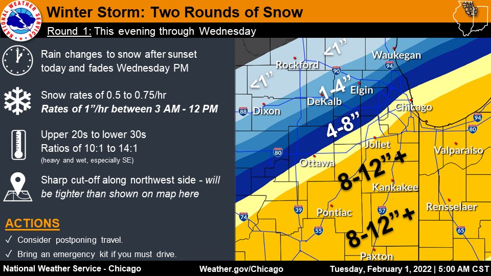
The majority of the snow is expected to fall beginning around 6 p.m. Tuesday and continuing through most of the day Wednesday, according to meteorologists at the National Weather Service in Romeoville. As much as 8 inches to 1 foot of snow could fall in the Chicago area and points south.
Forecasters said the storm will come with a sharp gradient, meaning areas nearby could get drastically different amounts of snow. Residents of the northwest suburbs may not get any snow accumulation, meteorologists said.
At the moment we have hazy but sunny skies and 5.5°C, the warmest we've had since the 18th, when it got up to 5.9°C. One forecast says we'll get 7°C by noon, another says we'll get rain by 3...who knows? But by this time tomorrow, either we'll have a ton more snow on the ground or we won't.
Update: National Weather Service Chicago published this graphic earlier:
The next forecast should come out in about an hour or so.
Copyright ©2026 Inner Drive Technology. Privacy. Donate!