Breaking news:
Nearly 300,000 New York City residents were told Friday to get out of their homes in a first-ever mandatory evacuation as officials ordered an unprecedented shutdown of the city’s mass transit system for Saturday in advance of Hurricane Irene, raising the prospect of a singular scramble as hundreds of thousands of residents try to get out of the massive storm’s way.
Mayor Michael Bloomberg ordered an evacuation by 5 p.m. Saturday for low-lying areas that house about 270,000 people. Meanwhile, Gov. Andrew M. Cuomo said subways, buses and commuter trains in the city, on Long Island and in the northern suburbs will begin their final runs around noon Saturday.
Officials earlier ordered Fire Island evacuated, starting half an hour ago.
Hurricane Irene, currently category 2 on the Staffir-Simpson scale, looks like it's heading straight for New York City. Both the NYC and New Jersey emergency management agencies have published maps (pdf) showing the likely flood zones for various categories of hurricanes. They're scary.
I used to live in Brooklyn Heights, N.Y., and Hoboken, N.J. Both areas would be affected by a category 1 hurricane. My place in Hoboken, in fact, was only 2 m above sea level. My stuff would probably be OK—I lived on the fourth and fifth floors—but a moderate storm surge would likely flood the entire city of Hoboken, and make it impossible to live there for weeks.
I hope all my friends in the New York Metro are taking reasonable steps to protect themselves and whatever stuff they can get out. It's going to be a wet weekend in the Northeast...
Update, 13:27 CDT: New York City and the surrounding area have decided to shut down all commuter train, subway, and Amtrak service in the region starting at noon tomorrow.
We're still three weeks from meterological autumn and we've already had the wettest summer in 54 years and the second-wettest ever:
The new rains are to fall in the midst of the Chicago area's wettest meteorological summer (the period which began June 1) in 54 years. A total of 420 mm has occurred to date which makes this the second wettest summer to date since the official observational record began here in 1871. That amount is nearly twice the 140 year average to date of 219 mm.
And what do we have in today's forecast? Yup. Rain.
At least it's only getting up to 26°C this weekend. I have my windows open for only the second time since July 7th.
Last night, after getting back from San Antonio, I opened the windows for the first time in nearly six weeks. We had, I believe, one of the hottest and stickiest Julys I've ever experienced. But yesterday when I got home the temperature was 23°C and dropping—finally cooler outside my air-conditioned apartment than inside it.
Unfortunately for my colleagues down in Texas, it's no cooler there:
| Day | San Antonio | Chicago |
|---|
| Sun Aug 7 | 38°C | 30°C |
| Mon Aug 8 | 38°C | 27°C |
| Tue Aug 9 |
39°C | 27°C |
| Wed Aug 10 | 39°C | 25°C |
| Thu Aug 11* | 40°C | 24°C |
* forecast
I understand, however, that they have beautiful winters....
Six months ago, at North Avenue Beach in Chicago:
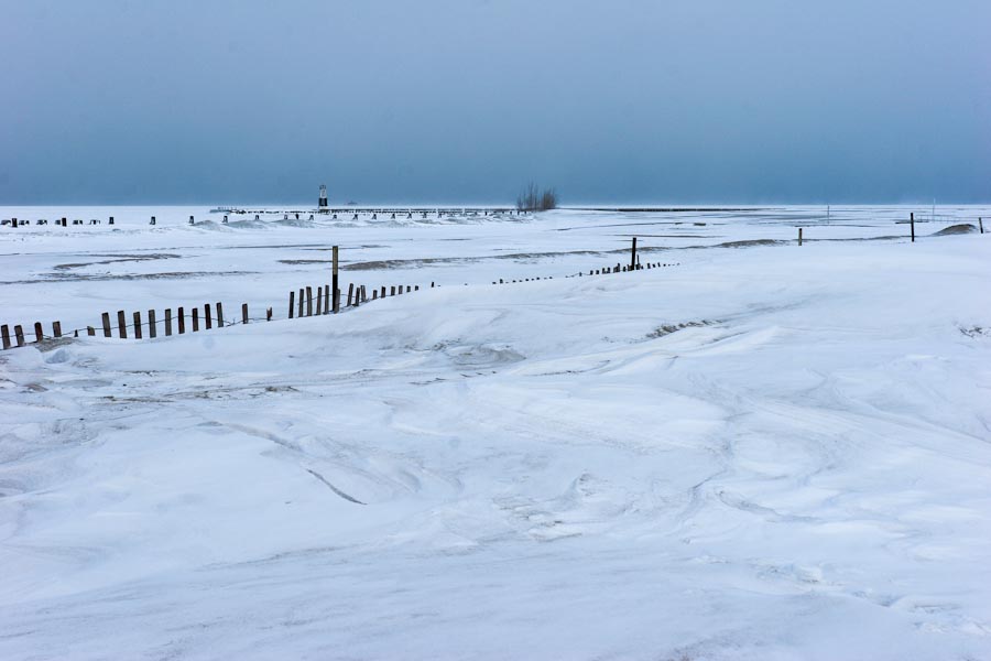
2 February 2011, Canon 20D at ISO-100, 1/250 at f/11, 27mm, near here.
I should have posted this photo a couple of days ago, when Chicago baked in near-40°C heat. Today's forecast calls for a mostly-pleasant 27°C under sunny skies.
Go back and relive those few days last February when it gets hot again.
The Tribune today has this graph showing the extreme precipitation we've had this year:
.jpg)
So far in 2011, Chicago has not only experienced its wettest year ever, but we've almost reached our annual normal rainfall total:
With the record (283 mm) July rains adding on to already above-normal precipitation prior to this month, Chicago's official total for 2011 has reached 858 mm - or 351 mm above normal at this point in the season. Chicago's official rain gage at the O'Hare International Airport observing site has now registered 93 percent of the normal annual 921 mm.
Today, however, it's sunny and clear, and not quite as hot as it has been recently.
Remember Tuesday, when we were only 13 mm away from having the wettest July in history? Thanks to a storm that dumped a squishy 259 mm of rain on nearby Dubuque, Iowa, Chicago's rainfall this month reached 248 mm, beating the old record of 243 mm set in 1889.
Today's forecast calls for even bloody more rain:
Showers and thunderstorms likely. Mostly cloudy, with a high near 32°C. Heat index values as high as 37°C. Southwest wind between 10 and 15 km/h. Chance of precipitation is 70%. New rainfall amounts between 5 and 7.5 mm possible.
At 7am, the temperature of 23°C comes with a dewpoint temperature of 22°C, which is the scientific way of saying it's warm and sticky.
Let's see...warmer summers, more extreme weather, much more moisture in the atmosphere...saw that one coming.
Chicago is still experiencing weather more suited for the jungles of Cambodia:
For a 12th consecutive day Wednesday, Chicago's lows have registered 22°C or higher—the first time that's happened in 12 years and only the fourth time such a long string of warm nighttime lows has been observed at Midway Airport since 1928.
And it's still raining: another 111 mm fell on parts of the area this morning.
A weekend in Canada starts to look very appealing...
Chicago this year has not only gotten almost enough rain to hit a new record, but it's also gotten more than enough heat:
July's 230 mm of rain at O'Hare places the month only 13 mm away from July's 122 year old record of 243 mm recorded in 1889. A more typical July would have a rainfall tally closer to 67 mm by now—just a third as much as has fallen this month. ...
July's opening 26 days are averaging 26.2°C. That makes the month the warmest at O'Hare since weather readings were first archived at the site beginning in 1959. The 26.2°C average ranks as the 4th warmest July 1-26's over the full term of Chicago weather records spanning 141 years and taken at 12 different sites in the city since 1871.
Hot and wet: my favorite. (There's a joke in there somewhere...) When is October?