With yesterday's temperatures more like April than January, Chicago magazine's explanation of it is timely:
So what is going on? It's the warmest La Niña on record. That brings the global temperature down, but causes different effects in different places. Chicago is going through a near-record warm spell—strong La Niñas correlate with above average temperatures, like the 18°C we hit in 1989 when the mean January max was 11°C, 2°C higher than this month's mean. Meanwhile, Alaska and northern Europe are suffering through deadly cold snaps.
This came to me through the WGN weather blog, which in the same story points out that groundhogs are less accurate than random chance at predicting the weather. Just a heads-up for tomorrow.
The normal temperatures in Chicago for January 31st are a low of -8.3°C and a high of 0°C.
Right now, the temperature is 13°C; the low last night was 7°C
The normal temperatures in Chicago for April 9th are a low of 2°C and a high of 13°C.
That is all.
Via Sullivan, a snippet of conversation between Bob Dole and Newt Gingrich in the 1990s:
"Why do people take such an instant dislike to me?" asked a perplexed Gingrich, to whom Dole bluntly explained: "Because it saves them time."
In unrelated news, Parker and I are about to walk around in abnormally warm, sunny weather on what is statistically the coldest day of the year in Chicago. This is the warmest winter in 78 years, with the fewest sub-freezing maximum temperatures in 40 years. (Today was above freezing until a cold front edged through this morning; right now it's -1°C.)
Two items I haven't had time to read fully, and intend to do over the weekend:
That is all.
Oh, except: tomorrow the sun sets in Chicago at 5pm for the first time since November 5th.
Chicago is experiencing the mildest winter in 78 years, which means anyone complaining about the weather lately needs serious mocking:
Though this season has produced some wintry moments, last Friday's snowstorm among them, the vast majority of days---82 percent of them---have posted above normal temperatures. What's more, we could find only 11 winters of the past 141 for which official weather records exist, which have been milder up to this point in time.
Chicago's average temperature since Dec. 1 is running 0.2°C, well above the 141-year average of -2.9°C and a stunning 6.3°C warmer than the same period a year ago. That's a difference which suggests many Chicago area residents have required 17 percent less home heating.
A multi-day burst of frigid arctic air heads into the area in waves late this week into the coming weekend. Any one of them, if fully developed, could produce several inches of snow. The first is due later Friday into Friday night---a second swings into the area just ahead of sharp cooling predicted Saturday into Saturday night.
The arctic chill will come and go fairly expeditiously, as has been the case with previous cold spells all season.
The mild disappointment Parker might feel about our weather this winter does not bother me at all. In Chicago, we say our weather builds character. After [redacted] Chicago winters in my lifetime, with a few in New York, Lisbon, and Raleigh for comparison, I'll take one year off from character-building happily.
I'm at O'Hare for the first time this year, wicked early for my flight. This happened because I left lots of time to dig my car out, get Parker sorted, get to the airport, etc. As it turns out, the howling wind cleared my car overnight; there was no traffic; the main roads are already clear because, really, it wasn't that much snow; and when I got to remote parking, an enormous pickup truck pulled out of a parking space, leaving a patch of cleared ground the size of Connecticut. So...I brought a Kindle, and my flight is on time. No stress, no worries, no checked baggage.
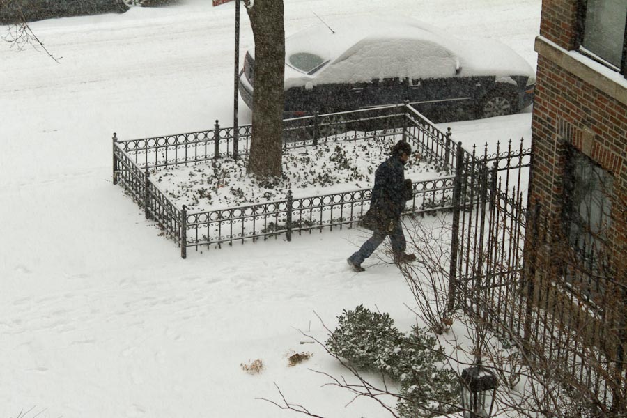
Working at home today (thus the earlier post with the dog). This is why:
The National Weather Service says it might melt on Sunday.
If Parker could have read this, he'd have been looking forward to this all day:
Yes, I know, I've posted remarkably similar videos before. Who cares? It's a dog having fun in the snow, which I think has universal appeal.
My team are all working from home today because we have the technology to do so, and we saw this:
A WINTER STORM WARNING REMAINS IN EFFECT FROM 9 AM THIS MORNING
TO MIDNIGHT CST TONIGHT.
* TIMING...SNOW WILL DEVELOP DURING THE MID TO LATE MORNING HOURS
AND CONTINUE THROUGH THIS AFTERNOON...ENDING TONIGHT. THE
HEAVIEST SNOWFALL WILL OCCUR THIS AFTERNOON.
* ACCUMULATIONS...SNOWFALL TOTALS OF 5 TO 8 INCHES CAN BE
EXPECTED.
* HAZARDS...SNOW WILL FALL HEAVILY AT TIMES RESULTING IN REDUCED
VISIBILITIES AND SNOWFALL RATES OF AROUND ONE INCH PER HOUR AT
TIMES.
* IMPACTS...ACCUMULATING SNOW WILL CAUSE SIGNIFICANTLY INCREASED
TRAVEL TIMES...RESULTING IN A PARTICULARLY TREACHEROUS COMMUTE
THIS AFTERNOON. IN ADDITION...VERY COLD TEMPERATURES IN THE
TEENS WILL MAKE SALT LESS EFFECTIVE AND COMBINE WITH HEAVY
SNOWFALL RATES TO MAKE IT HARDER FOR ROAD CREWS TO KEEP ROADS
CLEAR OF SNOW AND ICE. THE SNOW WILL ALSO RESULT IN SIGNIFICANT
DISRUPTIONS TO AIR TRAVEL AS WELL.
PRECAUTIONARY/PREPAREDNESS ACTIONS...
A WINTER STORM WARNING FOR HEAVY SNOW MEANS SEVERE WINTER WEATHER
CONDITIONS ARE EXPECTED OR OCCURRING. SIGNIFICANT AMOUNTS OF SNOW
ARE FORECAST THAT WILL MAKE TRAVEL DANGEROUS. ONLY TRAVEL IN AN
EMERGENCY. IF YOU MUST TRAVEL...KEEP AN EXTRA FLASHLIGHT...
FOOD...AND WATER IN YOUR VEHICLE IN CASE OF AN EMERGENCY.
Parker is also working from home. If he could read, his attitude toward the weather warning might differ slightly from mine. On the other hand, we're both in the same room, which I think makes him happy anyway.
Updates and photos as events warrant.
A couple of things have happened on two issues I mentioned earlier this week:
That is all for now. We in Chicago are bracing for 15 cm of snow tomorrow, so there may be Parker videos soon.
Oh, and: Kodak actually did file for bankruptcy protection today.