Geography is fun. It explains how Canadian airline WestJet can manage their newest trans-Atlantic flight which gets to Dublin in a little more than 4 hours using a 737-700:
Dublin itself might not be that strange, but this isn’t coming from a big city. No, it’s actually going to be a flight from St John’s, way out in Newfoundland. The metro area, if you can call it that, has almost 200,000 people. That’s good enough to be the 20th largest metro area in Canada. Yeah… 20th.
For WestJet, there is very little at stake here. The flight is surprisingly short to those of us who don’t pay much attention to Canadian geography. Remember how I said that WestJet already flies from St John’s to Orlando? Dublin is less than 25 miles further from St John’s. Via Great Circle Mapper…
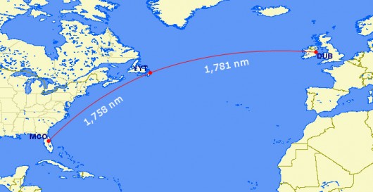
You always think of Transatlantic flying requiring long flights, but St John’s is so far out there that the eastbound flight is scheduled gate-to-gate at a mere 4h15m. It’s shorter than Vancouver to Toronto. Heck, it’s shorter than Phoenix to Philly. So this will be easy for the airline’s 136-seat 737-700 to operate.
It leaves St John’s at 1115p and arrives Dublin at 7a. It turns around quickly, departing at 820a, getting back to St John’s at 955a. WestJet likely would just leave that airplane overnight in St John’s otherwise, so the amount of extra aircraft time being used here is minimal.
The 3,300 km flight is just a little farther than L.A. to Atlanta (3,150 km) and a little closer than Washington to Las Vegas (3,350 km), and those city pairs are easily served by 737s today.
This little app is fun. Red are places I've been to but not stayed overnight; amber indicates at least one overnight; blue shows multiple visits; and green means I've lived, worked, or spent more than 30 aggregate days there:
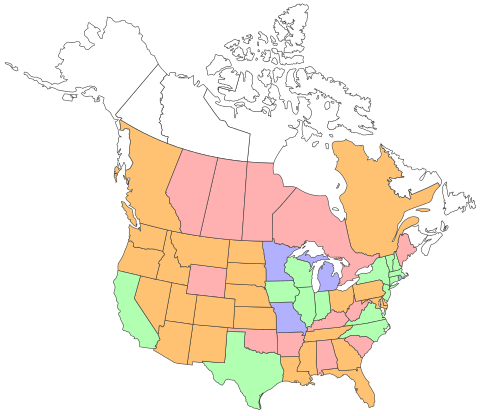
Clearly I need to visit the Maritimes and Territories. Oh, and Alaska and Hawaii.
Colin Woodward, writing in this quarter's Tufts alumni journal, summarizes his book about the regional views of violence in the U.S—dividing us up into 11 "nations" with cohesive cultural and social histories:
Beyond a vague awareness that supporters of violent retaliation and easy access to guns are concentrated in the states of the former Confederacy and, to a lesser extent, the western interior, most people cannot tell you much about regional differences on such matters. Our conventional way of defining regions—dividing the country along state boundaries into a Northeast, Midwest, Southeast, Southwest, and Northwest—masks the cultural lines along which attitudes toward violence fall. These lines don’t respect state boundaries. To understand violence or practically any other divisive issue, you need to understand historical settlement patterns and the lasting cultural fissures they established.
The original North American colonies were settled by people from distinct regions of the British Isles—and from France, the Netherlands, and Spain—each with its own religious, political, and ethnographic traits. For generations, these Euro-American cultures developed in isolation from one another, consolidating their cherished religious and political principles and fundamental values, and expanding across the eastern half of the continent in nearly exclusive settlement bands. Throughout the colonial period and the Early Republic, they saw themselves as competitors—for land, capital, and other settlers—and even as enemies, taking opposing sides in the American Revolution, the War of 1812, and the Civil War.
There’s never been an America, but rather several Americas—each a distinct nation. There are eleven nations today. Each looks at violence, as well as everything else, in its own way.
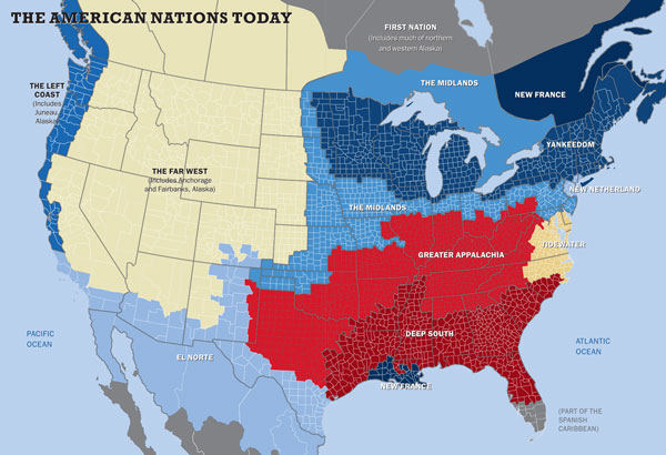
I'm usually suspicious of neat geographical distinctions, but it looks like I'll be putting this on my to-be-read stack (which is now larger than it was two years ago).
The Chicago-based Council on Tall Buildings and Urban Habitat has ruled that One World Trade Center is taller than Willis Tower:
The decision by the Chicago-based Council on Tall Buildings and Urban Habitat hinged on whether the tower's mast was a spire, which counts in height measurements, or an antenna, which doesn't.
The decision will end Willis Tower's reign of 40 years as the nation's tallest building.
The announcement culminated weeks of speculation about the ruling, which drew widespread attention because it would finally settle the issue of whether Chicago or New York could claim bragging rights to having the nation’s and the Western Hemisphere’s tallest building, as well as whether One World Trade Center would achieve the symbolic height of 541 m.
Willis Tower, completed in 1974 and once the world’s tallest building, is 442 m tall. Dubai’s Burj Khalifa, the current holder of the title, is 828 m tall.
The decision means One World Trade Center is the 3rd tallest building in the world, and drops Willis Tower to 10th place overall.
Boo.
The flights, between Newark, N.J., and Singapore, is the longest in the world:
The two all-business-class flights, which operate between Singapore and Newark, New Jersey, take around 19 hours and cover 15,300 km. But late last month, Singapore airlines announced that it would be cancelling the services, along with another between Singapore and Los Angeles that is almost as long.
The title for the world's longest flight...will now shift to Qantas, which operates a 13,800 km service between Sydney and Dallas.
Hey, wait a minute: Qantas is a oneworld carrier. How many frequent-flier miles does that cost again? Here it is: 37,500 for coach, 62,500 for business, and 72,500 for first. Each way.
I'll keep saving them.
Completely swamped today by a production error on an application I hardly ever work on. The problem was around something I'd written, but not caused by anything I wrote; still, it fell to me to fix the problem, which caused me to fall behind in everything else.
I have a bunch of Chrome tabs open with things I probably can't get to today:
That is all for now.
Cranky Flier explains:
Dallas is an increasingly large hub of business, and it sees no flights to Hong Kong today. It can also provide connections to a lot of places around the Midwest and South that don’t have single stop connections today. Look no further than joint venture-partner Qantas to see how that works. Qantas abandoned San Francisco and decided to run a flight to Dallas instead. It’s such a long flight that a stop in Brisbane is required on the westbound trip, but it’s apparently worth it.
That all sounds good, but there’s an even bigger benefit when it comes to Asia flying… Latin America.
Flying from Asia to Latin America is really far and requires stopping somewhere. To give you an idea, connecting the two financial capitals of Hong Kong and Sao Paulo would require flying more than 9,700 nautical miles. You know the longest route in the world today, Newark to Singapore? That’s 1,500 nm shorter. So you need to stop somewhere. And today, the options aren’t great. But Dallas provides a real opportunity to make for simple connections between Hong Kong and Latin America.
I'll be a beneficiary of this new strategy this autumn. More on that later.
Nate Cohn draws the map of these 61 United States:
What would happen if all of them succeeded? Each new state would get two senators and its share of electoral college votes. We ran the numbers and recalculated the 2012 presidential race.
In this bizarro United States, the GOP would have a structural advantage in the expanded Senate, and Barack Obama would have had a tighter fight against Mitt Romney in the electoral college (which he won, in reality, 332–206).
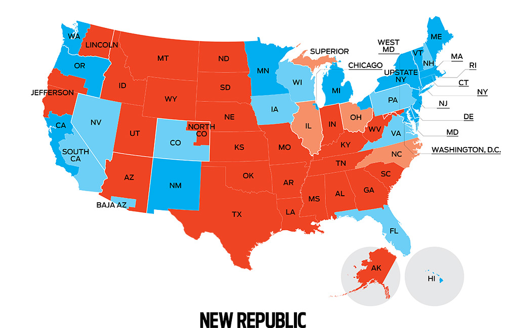
Of course, Cohn assumes that once the states seceded from their parent states—unlikely, in cases where the new states would reverse the existing state's party affiliation—the other states would let them in.
It's an interesting statistics issue, but alas, we're stuck with Texas and the rest of the former slave states that want to re-litigate Article IV.
As London continues to suffer with perfect weather this weekend, I'm taking a moment to get in from the cool sunny breezes and small cumulus clouds obscuring almost 10% of the sky. Yesterday the temperature soared to an unimaginable 24°C, causing Londoners to seek solace by standing outside pubs in groups drinking lagers. Today things have cooled off to more realistic levels (19°C right now), but the sun continues to make Londoners miserable and wait the restoration of normal weather.
Anyway, I've been meaning to post this map, which shows the U.S. population by race—one dot per person. Here's Chicago:
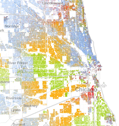
The yellow area south and west of the Loop are mostly African-Americans; you can see the abrupt change where the Austin neighborhood meets Oak Park on the west side. White people are blue dots, so purple-ish areas are well-integrated, while bluer areas are not.
Other parts of the country have different stories. Play with the map and take a look.
The friend who posted this roundup said simply, "Nerdgasm:"
Writing Systems of the World
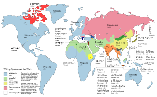
By Maximilian Dörrbecker (Chumwa) (Own work) [GFDL, CC-BY-SA-3.0 or CC-BY-SA-2.5], via Wikimedia Commons
Take a look.