CATO institute fellow Steve Hanke and Johns Hopkins physics professor Dick Henry advocate eliminating time zones:
The plan was strikingly simple. Rather than try to regulate a variety of time zones all around the world, we should instead opt for something far easier: Let's destroy all these time zones and instead stick with one big "Universal Time."
While it may ultimately simplify our lives, the concept would require some big changes to the way we think about time. As the clocks would still be based around the Coordinated Universal Time (the successor to Greenwich Mean Time that runs through Southeast London) most people in the world would have to change the way they consider their schedules. In Washington, for example, that means we'd have to get used to rising around noon and eating dinner at 1 in the morning. (Okay, perhaps that's not that big a change for some people.)
Washington Post writer Adam Taylor interviews the two cranks men to get the whole story. They also advocate for a universal calendar that includes an extra week belonging to no specific month between December and January.
There is some reason to suspect that the duo are not entirely serious...
Software developer Todd Schneider has analyzed 22 million CitiBikes trips (the New York equivalent of Chicago's Divvy). He's even got some cool animations:
If you stare at the animation for a bit, you start to see some trends. My personal favorite spots to watch are the bridges that connect Brooklyn to Lower Manhattan. In the morning, beginning around 8 AM, you see a steady volume of bikes crossing from Brooklyn into Manhattan over the Brooklyn, Manhattan, and Williamsburg bridges. In the middle of the day, the bridges are generally less busy, then starting around 5:30 PM, we see the blue dots streaming from Manhattan back into Brooklyn, as riders leave their Manhattan offices to head back to their Brooklyn homes.
Sure enough, in the mornings there are more rides from Brooklyn to Manhattan than vice versa, while in the evenings there are more people riding from Manhattan to Brooklyn. For what it’s worth, most Citi Bike trips start and end in Manhattan. The overall breakdown since the program’s expansion in August 2015:
- 88% of trips start and end in Manhattan
- 8% of trips start and end in an outer borough
- 4% of trips travel between Manhattan and an outer borough
There are other distinct commuting patterns in the animation: the stretch of 1st Avenue heading north from 59th Street has very little Citi Bike traffic in the morning, but starting around 5 PM the volume picks up as people presumably head home from their Midtown offices to the Upper East Side.
Schneider previously analyzed 1.1 billion New York taxi trips.
Salon's Seth Stevenson highlights the Cartography and Geographic Information Society's "Best of Show" map from this year. It may not be the best map of the U.S. ever drawn, but wow, it's impressive:
David Imus worked alone on his map seven days a week for two full years. Nearly 6,000 hours in total. It would be prohibitively expensive just to outsource that much work. But Imus—a 35-year veteran of cartography who’s designed every kind of map for every kind of client—did it all by himself. He used a computer (not a pencil and paper), but absolutely nothing was left to computer-assisted happenstance. Imus spent eons tweaking label positions. Slaving over font types, kerning, letter thicknesses. Scrutinizing levels of blackness. It’s the kind of personal cartographic touch you might only find these days on the hand-illustrated ski-trail maps available at posh mountain resorts.
A few of his more significant design decisions: Your standard wall map will often paint the U.S. states different colors so their shapes are easily grasped. But Imus’ map uses thick lines to indicate state borders and reserves the color for more important purposes—green for denser forestation, yellow for population centers. Instead of hypsometric tinting (darker colors for lower elevations, lighter colors for higher altitudes), Imus uses relief shading for a more natural portrait of U.S. terrain.
This object—painstakingly sculpted by a lone, impractical fellow—is a triumph of indie over corporate. Of analog over digital. Of quirk and caprice over templates and algorithms. It is delightful to look at. Edifying to study. And it may be the last important paper map ever to depict our country.
I may have to buy one. The 1:4,000,000 version is only $14, folded.
I have three books in the works and two on deck (imminently, not just in my to-be-read stack) right now. Reading:
On deck:
- Kevin Hearne, "Iron Druid Chronicles" book 8: Staked.
- Kim Stanley Robinson, "Mars" trilogy book 2: Green Mars.
Meanwhile, I have these articles and blog posts to read, some for work, some because they're interesting:
Time to read.
Meanwhile, I seem to have a cold. Yuck.
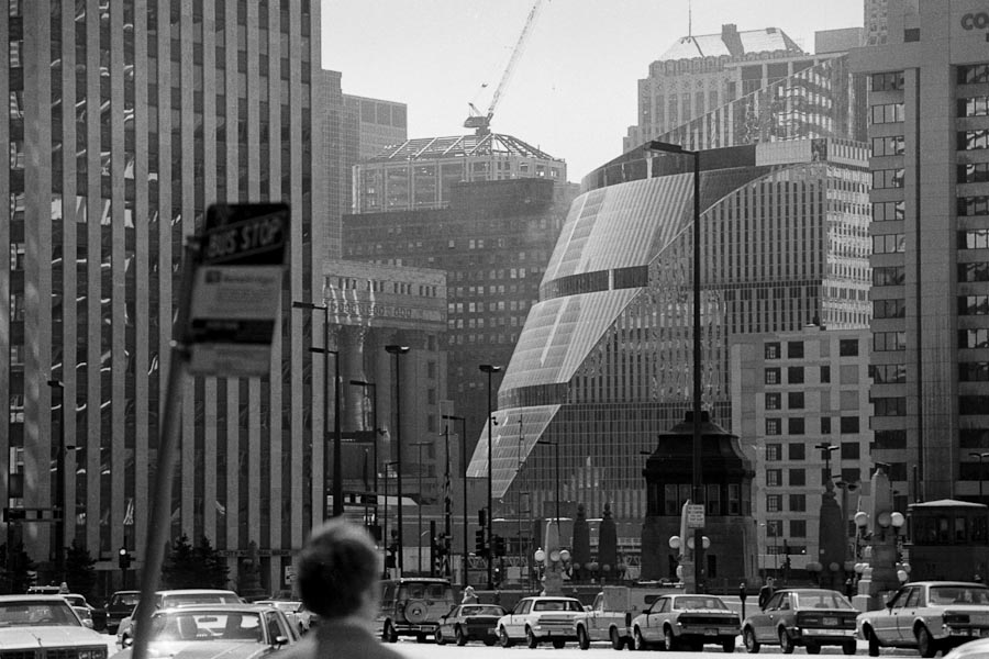
I've meant to post this for a while. Here's a photo looking south-west from a point just southwest of the intersection of Wacker and Michigan, here in Chicago, in April 1986:
And here's a similar view today. Note that you can no longer see the Thompson Center, City Hall, or anything else beyond the row of skyscrapers erected on Wacker between Wabash and Clark since then:
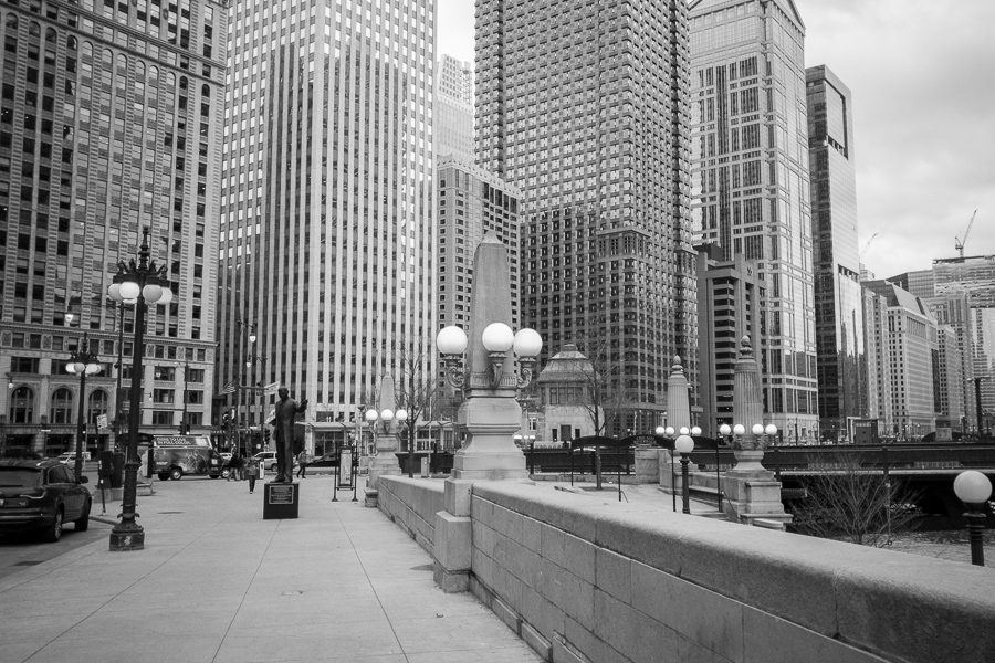
The photos aren't from the same vantage point, because this afternoon I only had my phone and not my SLR. I will try to get a photo from approximately the same location and using the same focal length (probably 210mm) soon.
On this day 180 years ago (28 January 1836), John L. Wilson purchased 33 hectares of land about 16 km from the city, by what is now 83rd and Cottage Grove. At the time it was a swath of prairie two hours outside Chicago. But through a series of missteps, slow City workers, and a very long-lived lawsuit, no one developed the land until 1940, by which time the city had grown to surround the lot on all sides:
The property was so remote—and the value so depressed—that nobody paid much attention to it for nearly 40 years. Then, in 1875, Isaac Palmer discovered that the original land patent had been issued in his name by mistake. He decided to cash in on it.
So now the matter went to the Superior Court of Cook County. By the time the Illinois Supreme Court got the case, the City of Chicago was involved, as well as the successors to Wilson and Palmer. In 1887 the Supreme Court ruled that the Wilson successors had legal title to the property. The City of Chicago also had a valid mortgage of $1,500 against it, with 10% annual interest dating back to the unpaid October 1836 mortgage.
Except there was yet another complication—most land records had been lost in the 1871 Chicago Fire. The further details of the dispute don’t need to be elaborated here, except to say that many lawyers were kept busy over the next fifty years, with the 80-acre plot remaining vacant while the rest of the area was built up.
On August 4, 1939 the drama ended. Compound interest over 102 years had ballooned the defaulted $1,500 mortgage to $34,755,000. Because of all the mistakes various governments had made over the years, Janet Fairbank—the last holder in the chain of title from original patentee John L. Wilson—was allowed to settle the debt and have clear title to the property on payment of $30,000.
For what it's worth, $1,500 in 1837 is about $38,000 today, and $34.8m in 1939 is around $590m today.
This means I have some time to digest this over the weekend:
I might have a chance to read this weekend. Perhaps.
The Economist reports this week that the Tsujiki fish market will close at the end of November:
Squeezed between the Sumida river and the Ginza shopping district, Tsukiji is creaking at the seams. Some 60,000 people work under its leaky roof, and hundreds of forklifts, carrying everything from sea urchins to whale meat, careen across bumpy floors. The site’s owner, the city government, wants it moved.
The final blow was Tokyo’s successful bid to host the 2020 Olympics. A new traffic artery will cut through Tsukiji, transporting visitors to the games’ venues. Part of the site will become a temporary press centre, says Yutaka Maeyasui, the executive in charge of shifting the market. Our time is up, he says, glancing around his decrepit office. The site has become too small, old and crowded. An earthquake could bring the roof down.
I'm planning to re-visit Tokyo in October, so I might just get in under the wire. When I visited in November 2011, I didn't get up early enough to watch the fish auction (which starts around 4am); this autumn, I may force myself to see one of the last ever.
As the work week slowly grinds down, I've lined these articles up for consumption tomorrow morning:
And now it's off to the barber shop. And then the pub.
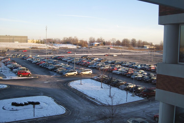
It's a slow, agonizing death:
A report from the real estate service firm NGKF released late last year provides new numbers on an ongoing phenomenon: the slow, agonizing death of the American office park. The report looks at five far-flung office tenancy submarkets—Santa Clara, in the San Francisco Bay Area; Denver; the O’Hare region in Chicago; Reston/Herndon outside of Washington, D.C.; and Parsippany, New Jersey—and finds a general aura of decline.
Between 14 and 22 percent of the suburban office inventory in these areas is “in some stage of obsolescence,” suggesting that between 600 million and 1 billion square feet of office space are far from ideal for the modern company and worker. That’s about 7.5 percent of the country’s entire office inventory.
I would almost rather go to prison than work in a suburban office park. I mean, take this one outside Cincinnati, for example. I can't believe I had to spend four weeks there: