...could be today, depending on which competing definition you use:
A blue moon is a full moon that is not timed to the regular monthly pattern. Most years have twelve full moons which occur approximately monthly, but in addition to those twelve full lunar cycles, each solar calendar year contains an excess of roughly eleven days compared to the lunar year. The extra days accumulate, so that every two or three years (7 times in the 19-year Metonic cycle), there is an extra full moon. The extra moon is called a "blue moon." Different definitions place the "extra" moon at different times.
- In calculating the dates for Lent and Easter, the Clergy identify the Lent Moon. It is thought that historically when the moon's timing was too early, they named an earlier moon as a "betrayer moon" (belewe moon), thus the Lent moon came at its expected time.
- Folklore gave each moon a name according to its time of year. A moon which came too early had no folk name – and was called a blue moon – bringing the correct seasonal timings for future moons.
- The Farmers' Almanac defined blue moon as an extra full moon that occurred in a season; one season was normally three full moons. If a season had four full moons, then the third full moon was named a blue moon.
- Recent popular usage defined a blue moon as the second full moon in a calendar month, stemming from an interpretation error made in 1946 that was discovered in 1999. For example, December 31, 2009 would be a blue moon according to this usage.
So, it's possible today's full moon is a blue moon. Or it's possible the next blue moon will occur November 21st. Or after some volcanic eruption which hasn't happened yet.
Regardless, enjoy it if you can. It only happens...infrequently.
It's time for the semi-annual update of the
Chicago sunrise chart. (You can get one for your own location at
http://www.wx-now.com/Sunrise/SunriseChart.aspx.)
An interesting note about 2010: the sunset on November 6th will be the latest sunrise in Chicago (7:30am) until 2021—and that, only within 4 seconds of precision.
|
Date
|
Significance
|
Sunrise
|
Sunset
|
Daylight
|
|
2010
|
|
3 Jan
|
Latest sunrise until Oct. 29th
|
07:19
|
16:33
|
9:14
|
|
27 Jan
|
5pm sunset
|
07:08
|
17:00
|
9:51
|
|
4 Feb
|
7am sunrise
|
07:00
|
17:10
|
10:09
|
|
20 Feb
|
5:30pm sunset
|
06:39
|
17:30
|
10:50
|
|
27 Feb
|
6:30am sunrise
|
06:29
|
17:39
|
11:09
|
|
13 Mar
|
Earliest sunrise until Apr. 18th
Earliest sunset until Oct. 25th
|
06:06
|
17:55
|
11:49
|
|
14 Mar
|
Daylight savings time begins
Latest sunrise until Oct. 17th
Earliest sunset until Sept. 18th
|
07:04
|
18:56
|
11:52
|
|
17 Mar
|
7am sunrise, 7pm sunset
12-hour day
|
06:59
|
19:00
|
12:00
|
|
20 Mar
|
Equinox 12:32 CDT
|
06:54
|
19:04
|
12:09
|
|
3 Apr
|
6:30am sunrise (again)
|
06:30
|
19:19
|
12:48
|
|
13 Apr
|
7:30pm sunset
|
06:14
|
19:30
|
13:16
|
|
22 Apr
|
6am sunrise
|
06:00
|
19:40
|
13:40
|
|
11 May
|
8pm sunset
|
05:35
|
20:01
|
14:25
|
|
16 May
|
5:30am sunrise
|
05:30
|
20:06
|
14:35
|
|
14 Jun
|
Earliest sunrise of the year
|
05:15
|
20:28
|
15:12
|
|
21 Jun
|
Solstice 06:28 CDT
8:30pm sunset
|
05:16
|
20:30
|
15:14
|
|
27 Jun
|
Latest sunset of the year
|
05:18
|
20:31
|
15:12
|
|
2 Jul
|
8:30pm sunset
|
05:20
|
20:30
|
15:10
|
|
17 Jul
|
5:30am sunrise
|
05:30
|
20:23
|
14:52
|
|
9 Aug
|
8pm sunset
|
05:53
|
20:00
|
14:06
|
|
16 Aug
|
6am sunrise
|
06:00
|
19:50
|
13:49
|
|
29 Aug
|
7:30pm sunset
|
06:14
|
19:29
|
13:16
|
|
14 Sep
|
6:30am sunrise
|
06:30
|
19:02
|
12:31
|
|
15 Sep
|
7pm sunset
|
06:31
|
19:00
|
12:29
|
|
22 Sep
|
Equinox, 22:09 CDT
|
06:38
|
18:48
|
12:10
|
|
25 Sep
|
12-hour day
|
06:41
|
18:43
|
12:00
|
|
3 Oct
|
6:30pm sunset
|
06:50
|
18:29
|
11:39
|
|
12 Oct
|
7am sunrise
|
07:00
|
18:14
|
11:14
|
|
21 Oct
|
6pm sunset
|
07:10
|
18:00
|
10:50
|
|
6 Nov
|
Latest sunrise until 6 Nov 2021
Latest sunset until Feb 28th
|
07:30
|
17:39
|
10:09
|
|
7 Nov
|
Standard time returns
Earliest sunrise until Mar 3rd
|
06:31
|
16:38
|
10:07
|
|
15 Nov
|
4:30pm sunset
|
06:40
|
16:30
|
9:49
|
|
2 Dec
|
7am sunrise
|
07:00
|
16:20
|
9:20
|
|
8 Dec
|
Earliest sunset of the year
|
07:06
|
16:20
|
9:14
|
|
21 Dec
|
Solstice, 17:38 CST
|
07:15
|
16:23
|
9:08
|
You can get sunrise information
for your location at wx-now.com.
I'm leaving this:

For this:
THE NATIONAL WEATHER SERVICE IN CHICAGO HAS ISSUED A WINTER
WEATHER ADVISORY FOR SNOW...WHICH IS IN EFFECT UNTIL 9 PM CST
THIS EVENING.
At least I'll get there earlier than planned. I tried to get on the 11:30, but because the 7:30 had left at 9:30, and the 9:45 was delayed, they put me on the 9:45 which actually leaves (we hope) at 11. So instead of 7 hours at home before traveling again tomorrow, I get 9. I hope.
Update: Well, the 9:45 actually now leaves at 1pm, in theory, leaving me almost exactly no better off than the original plan. We'll see.
That's Chicago's weather today. Except I'm not there, I'm here:
Also, if you live near a Peet's Coffee, they're giving away free cups of coffee all day.
You know the truly fun part about traveling through O'Hare five times in one week in December? Not knowing when that will happen:
Delta [says] it is about to issue a weather bulletin allow passengers in 10 states to change tickets without penalty starting today through Dec. 27th. Those states are Illinois, Indiana, Iowa, Kansas, Michigan, Minnesota, Nebraska, Wisconsin and North and South Dakota. They are encouraging folks to try to change travel plans to get out ahead of any storms if possible. Delta has hubs in Detroit and Minneapolis-St. Paul.
No one has started pre-canceling any flights yet – but stay tuned. That may happen tomorrow.
At least, if either of my next two flights gets[1] delayed, I'll be stuck in one of my two favorite cities in North America. Sigh.
[1] Note to the grammar police (you know who you are): "either...gets" is correct because "either" is a singular pronoun.
Washington looks quite pretty from the air with all the snow on the ground:
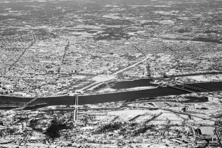
I'm confused. Yes, I see snow, and on the ground at DCA it seems to be about 30-35 cm deep, but in Chicago we'd find this annoying, not paralyzing. I wonder if Virginia still has the same number of snowplows as Chicago (which was true in 2003, the last time the area got "buried" like this). If so, maybe they want to examine some of the climate-change projections calling for more precipitation? Hmm.
Diane and Parker are a few minutes away. Not that I mind airport lounges, but I'll be happy to see them again after their ordeal.
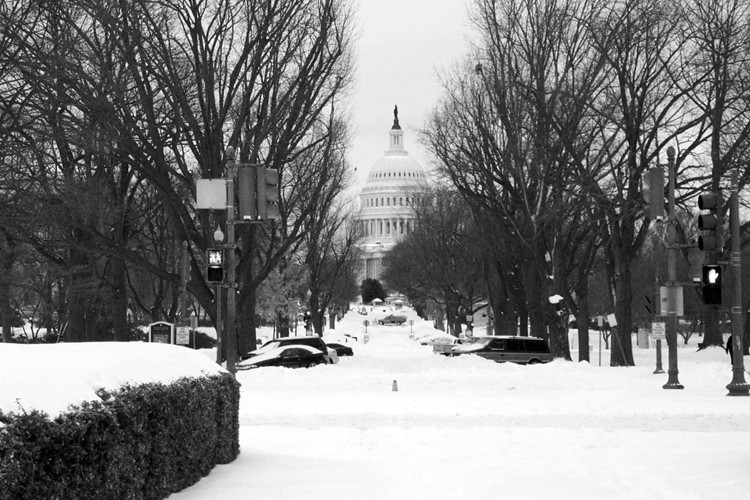
That's how much snow covers Washington, D.C., right now:
A major storm that broke all records for a December snowfall buried the Washington area Saturday, forcing authorities to suspend public transportation, declare a state of emergency and plead with residents to stay home.
Hundreds of airline flights were canceled, Metro stopped running trains to aboveground stations and shopping malls closed early because few customers could navigate treacherous roads to get there on the last weekend before Christmas.
But at 10 p.m. Saturday, it appeared that the fury of the great storm might be fading into flurries. Over the next two hours, "any additional accumulation will be light," the National Weather Service said.
Yet, it will be days before things return to normal. Metro said the suspension of bus and aboveground rail service, which went into effect Saturday, would continue Sunday morning when the system reopened.
At the snowstorm's peak in the afternoon, flakes fell at the rate of two inches an hour. Some areas, particularly in Southern Maryland, experienced wind gusts up to 64 km/h. The total measured snowfall at Reagan Airport at 8:58 p.m. was 41.4 cm, but it was as high as 58 cm elsewhere in the region. That would be more snow in a 24-hour period than the region typically gets in an entire winter. According to Weather Service statistics, the storm ranked among the biggest snowfalls in local history.
National Airport has reopened, which is helpful because in half an hour I'm heading over to O'Hare to get there. Diane and Parker stayed another night in Petersburg, Va.; we all hope they get up to Washington by the time my flight arrives. I-95 looks clear on the many traffic cameras set up along the way, but the streets inside the District may not be.
What fun. It was going to be a quick long weekend trip, too...
Yesterday I mentioned how helpful American Airlines was helping me avoid what promised to be an excruciating layover at O'Hare today. It turns out, Washington's weather is worse than even the most pessimistic forecasts:
A snowstorm of historic proportions is burying a wide swath of the Mid-Atlantic under as much as 30 to 90 cm of snow as the weekend gets underway. The Washington D.C. area is to end up among the locations hardest hit with as much as 60 cm of snow a possibility -- the heaviest accumulation to hit the nation's capital in at least six years and enough to grant the windy, rapidly intensifying system a spot among that city's Top 3 biggest snowstorms. Washington snow records date back to 1885.
It could be worse. We could be in Alaska, for example:
With all the snow in the Lower 48, it should be noted the port city of Valdez in southern Alaska has been hit with one of its heaviest weekly snow tallies ever. Snow began falling Monday and by Wednesday had totaled 1.7 m.... Additional spells of snow boost had boosted tallies to 2 m as Friday ended.
The phrase "heaviest in the last six years" refers to the February 2003 monster that stranded me in D.C. for two days:
Unfortunately, Parker and Diane are caught up in all this. They left last night for Washington to meet me there (I had to fly there because of airline fare rules, believe it or not), but only got as far as Petersburg, Va.. He seems comfortable enough, but I think he needs to get OFF THE BED. NOW.

So, I get an unexpected night in Chicago tonight, and they (I hope) get to drive up to D.C. in daylight without snowplows terrorizing them. They might have to stay in central Virginia another night, though. The forecast for D.C. doesn't look encouraging:
Today: Snow. The snow could be heavy at times. High near 29. North wind around 18 mph. Chance of precipitation is 100%. Total daytime snow accumulation of 8 to 12 inches possible.
Tonight: Snow, mainly before 4am. The snow could be heavy at times. Low around 27. North wind between 14 and 16 mph. Chance of precipitation is 90%. New snow accumulation of 2 to 4 inches possible.
Sunday: A chance of snow, mainly before 7am. Mostly cloudy, with a high near 33. Northwest wind around 15 mph. Chance of precipitation is 30%. New snow accumulation of less than a half inch possible.
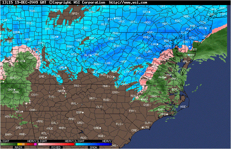
Nor does the radar image:
I hope that Virginia finds all (dozen) of its snowplows, and I hope Diane and Parker make it safely and quickly to D.C.
Original plan: Fly to Chicago tomorrow, then change at O'Hare for D.C. New plan: Fly to Chicago tomorrow, twiddle my thumbs at home, and fly to D.C. Sunday morning. Why? Because no one is flying to D.C. tomorrow:
The National Weather Service has issued a Winter Storm Warning for the entire [Washington] area, starting midnight Friday and lasting through 6 a.m. Sunday.
ABC 7 Meteorologist Chris Naille says the most of the region can expect 10 to 15 inches of snow, with up to 20 inches in spots along and east of I-95.
Parts of western and central Virginia could get up to 18 inches.
What fun. Fortunately, American Airlines has already gone into emergency mode, so when I called to see what my options were, they said "any plane Sunday."
So, I'll see everyone on Sunday.