The Republican National Committee has cancelled the first night of their quadrennial convention because of Tropical Storm Isaac:
That move essentially postpones the activities of the first of four scheduled days of the convention. But [RNC Chair Reince] Priebus said in a conference call with reporters that the details of the revised schedule were not yet settled, and could be announced as soon as Sunday.
"The Republican National Convention is going to take place. We know that we will officially nominate Mitt Romney and Paul Ryan," he said.
The impending hurricane aside, Republicans already did some last-minute reshuffling for their convention order, moving Ann Romney's speech to Tuesday from Monday because major television networks hadn't planned to broadcast the first night of the convention.
(Emphasis mine, impressed that the GOP can spin lemonade out of a hurricane.) Still, even though Isaac looks to brush Tampa on the cheek instead of hitting it on the nose as it appeared Friday, as an atheist I'm enjoying the theological implications of the right-wing religious party having their biggest event in four years disrupted by a weather event.
Will they moderate their views about human-caused climate change? Will they whistle past this graveyard? Will monkeys fly out of my butt while I'm typing this? I think we know the answer to all three questions.
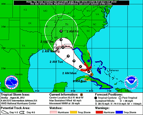
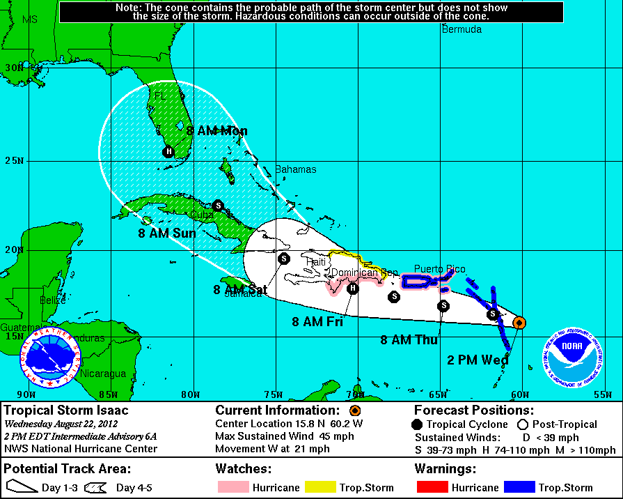
The National Hurricane Center predicts that Tropical Storm Isaac, currently smashing through the windward islands, may strike Tampa during the GOP convention:
Of course, five days out the forecast has tremendous uncertainty. The storm could change course or dissipate before hitting Florida, for example. But Tampa Mayor Bob Buckhorn, speaking about next week's GOP convention, is absolutely willing to call it off if they need to evacuate Tampa:
So, my question is, now that the religious right has all but taken over the Republican Party, what would it mean if an "act of God" shut down their convention in a Presidential election year?
This weekend's weather forecast in Chicago predicts the coolest weekend since May 12, 14 weeks ago. Through Sunday temperatures should be 3°C below normal (days in the low 20s, lows in the low teens), with sunny skies and cool northeast breezes. September, in other words.
The Tribune points out:
Only 6 of past 142 years have produced Aug. 18 overnight lows cooler than those expected by Saturday morning.
Not only will daytime readings be cooler than typical for mid August, nighttime lows will be cooler than normal as well, particularly in areas farthest from the city and Lake Michigan---both of which temper early season cool spells by adding heat.
Friday night/Saturday morning's predicted 12°C low would become Chicago's chilliest minimum temperature in over two months and would qualify as one of the six coolest early season readings for the date since 1871.
It will warm up mid-week, though not to the temperatures we suffered through in the warmest July in history last month. I've got the windows open, and I'll probably be able to keep them open until Wednesday.
Parker likes having the windows open as well, but he's not used to hearing the neighbors—in particular, the neighbors' dogs. I hope he figures it out, because the random, single woofs at 2am are really aggravating.
The WGN Weather Blog reported this weekend that the El Niño-Southern Oscillation has turned warm in the past couple of months, and is getting warmer. The Climate Prediction Center started noticing in July:
Nearly all of the dynamical models favor the onset of El Niño beginning in July - September 2012 (Fig. 6). As in previous months, several statistical models predict ENSO-neutral conditions through the remainder of the year, but the average statistical forecast of Niño-3.4 increased compared to last month. Supported by model forecasts and the continued warmth across the Pacific Ocean, there is increased confidence for a weak-to-moderate El Niño during the Northern Hemisphere fall and winter 2012-13. El Niño conditions are likely to develop during August or September 2012 (see CPC/IRI consensus forecast).
Normally, warm winters lead to warm summers in Chicago, with the pattern resetting in late Autumn. That is, even this record-breaking summer could be followed by a bone-chilling winter. But El Niño years tend to give Chicago warm, dry winters. I'm all for mild winters—except that mild winters tend to cause warm summers, which I am not in favor of.
At least autumn should be lovely here.
I got back home last night after spending a week in cool, California coastal weather. Apparently I brought some of it with me:
The return of sunshine this weekend is to send temperatures higher. It's a change which will be noticed given the fact it follows the first back to back below-normal days in over 6 weeks. Saturday's predicted 26°C high represents a 3°C increase from Friday's 24°C reading—and Sunday's 29°C tacks another 2°C on the day's peak reading.
But, while warm and eminently comfortable, the readings predicted Saturday and Sunday are the lowest of any weekend since June 2-3—10 weeks ago!
Yes, we're having the coolest weather in 10 weeks. I opened my windows when I got home, and I will likely keep them open through tomorrow afternoon, which would be the first time since early June I've kept them open for a full day.
It will get warmer this week, unfortunately, but after the warmest July in U.S. history we have to expect a warm August, September, and October.
Today, though, I'm really enjoying the weather.
It's not just Chicago; the Illinois State Climatologist has pronounced this year hotter than hell:
This year so far is the warmest and third driest on record. The statewide average temperature for January-July 2012 was 56.9 degrees, 5.5 degrees above normal. The statewide average precipitation for January-July was 357 mm, 249 mm below normal or 59 percent of normal.
Statewide Average Temperature Rankings for January-July
- 2012: 13.8°C
- 1921: 13.4°C
- 1987: 12.3°C
- 1998: 12.2°C
- 2006: 12.1°C
Statewide Average Precipitation Rankings for January-July
- 1936: 310 mm
- 1934: 344 mm
- 2012: 357 mm
- 1988: 371 mm
- 1914: 386 mm
That said, I'm sitting outside with my laptop on a lovely, clear 26°C night. The really awful heat returns tomorrow, though...
The month ended with Chicago Midway reporting its warmest July ever, while our official O'Hare station had the second-hottest ever:
Of all the summers on the books over Chicago's official observational record dating back to 1871, only the 1921 season managed a temperature higher than the 25.3°C reading on the books to date this year. That makes this the warmest opening two-thirds of a meteorological summer season here in 91 years.
The bleak rainfall situation continues across the area as this year's drought worsens. At 116 mm, this summer's rain tally ranks 23rd driest of the 142 years to which we can compare it.
And it's not over; the Climate Prediction Center published this map yesterday:
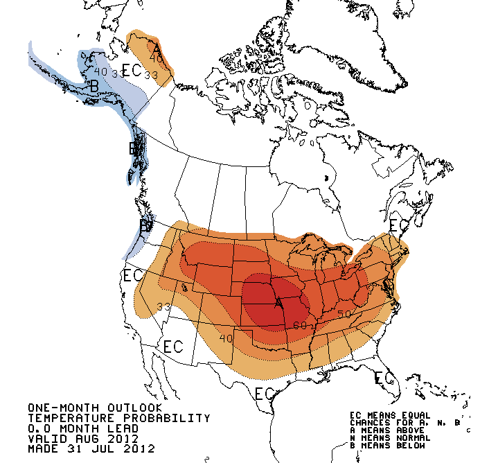
The good news is, we'll probably have a warm autumn, too...
Chicago's average temperature this July will probably wind up at 27.2°C, making it the third-warmest in history behind 27.3°C 1921 and 27.4°C 1955. (Normal is 23.3°C.)
Along with the near-record heat we've had more 32°C days so far than ever before. And it's not over:
Never before, over the term of Chicago's 142 year observational record, have so many 90s accumulated at such an early date.
July alone produced 18 days at or above 90---far beyond the seven considered normal, yet just shy of the 19 days of 90s recorded in 1955 and 1987—both record highs for the month.
History tells us we've likely NOT seen the last of the hot air. An estimated 35 percent (more than a third) of Chicago's remaining 90+degree temperatures have typically occurred from this date forward.
At least today and tomorrow should be cooler, 27°C today and 28°C tomorrow, before going back into the red zone on Thursday.
Roll on October...
Despite having two Atlantic named storms before June 1st, so far the tropical storm season has been eerily quiet with 4 named storms. Then I did a little poking around on the Intertubes and realized that no, we usually don't have that many by the end of July. With all the energy in the Northern Hemisphere atmosphere this summer, September might be more interesting than usual. But so far in July, we seem to be about average.
...because most of our maize corn is dying too:
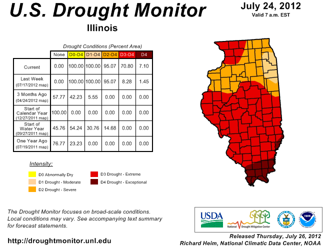
The latest U.S. Drought Monitor has expanded D3 “extreme” drought across Illinois. It went from 8 percent of the state last week to 71 percent this week. This major shift was based on a number of short-term drought indicators based on rainfall, streamflow, and temperature, as well as from widespread reports of significant crop and pasture losses.
Earlier this week, the USDA NASS reported that 66 percent of the corn crop, 49 percent of the soybean crop, and 91 percent of pasture was rated poor to very poor. Topsoil was rated at 91 percent poor to very poor and subsoil was rated 97 percent poor to very poor.
The hottest July ever in Chicago averaged 27.4°C; so far this month has averaged 27.8°C, though today and Saturday are forecast to be about normal.
Food prices, electricity expenses, health-care costs: all are higher this month than one would expect for July. Welcome to the 21st Century, where the weather is as if everyone has moved 800 km south.