The Daily Parker

Politics, Weather, Photography, and the Dog

My, it's warm

Sunday evening we had 4°C gloominess with gusty winds. Today we've got 28°C sunniness with gusty winds. We've also got a bunch of news stories to glance through while a build completes:

Cassie has plotzed on the sofa, probably from the heat and from spending all day yesterday at doggy day care.

And here's the CDC's latest chart:

Welcome back, kids

Endangered piping plovers Monty and Rose have returned to Chicago's Montrose Beach for the third year running:

The pair of endangered, migratory Great Lakes piping plovers have been spotted at Montrose Beach, the couple’s preferred mating ground for their third straight summer. The female Rose was discovered near the beach and natural dune area Sunday, while Monty’s presence at the North Side lakefront park was confirmed Monday afternoon, local birder Bob Dolgan said.

“It’s very exciting,” Dolgan said. “There are no guarantees when birds are traveling 1,000 miles. Hopefully this is the start of another successful summer for the birds.”

The bird couple has successfully nested along the beach for the last two years. Their first effort to nest at the beach resulted in a conservation effort, which caused beach volleyball games to be relocated and a music festival to be canceled.

Last year, the birds had the beach free of human interaction, as much of Chicago’s lakefront was off-limits during the height of the coronavirus pandemic.

But this year’s effort could be aided by the Chicago Park District’s recent decision to expand the plovers’ favored nesting grounds.

Earlier this month, the Park District approved a plan to add just over three acres of Montrose Beach to the adjacent Montrose Dune Natural Area. The beach’s easternmost portion — which Monty and Rose have chosen as their yearly nesting and foraging ground — has been absorbed into the natural area.

Monty and Rose, sittin' in a tree...or on the ground...whatevs. Nice to have them back.

Catching up

Even though things have quieted down in the last few days (gosh, why?), the news are still newing:

Finally, last August's derecho caused "the most damage in the least amount of time" of any weather disaster on record.

How is it already 4pm?

I've had an unusually busy (and productive!) day, so naturally, the evening reading has piled up:

Finally, National Geographic has a slideshow of the world's best ghost towns.

Weather, just more of it

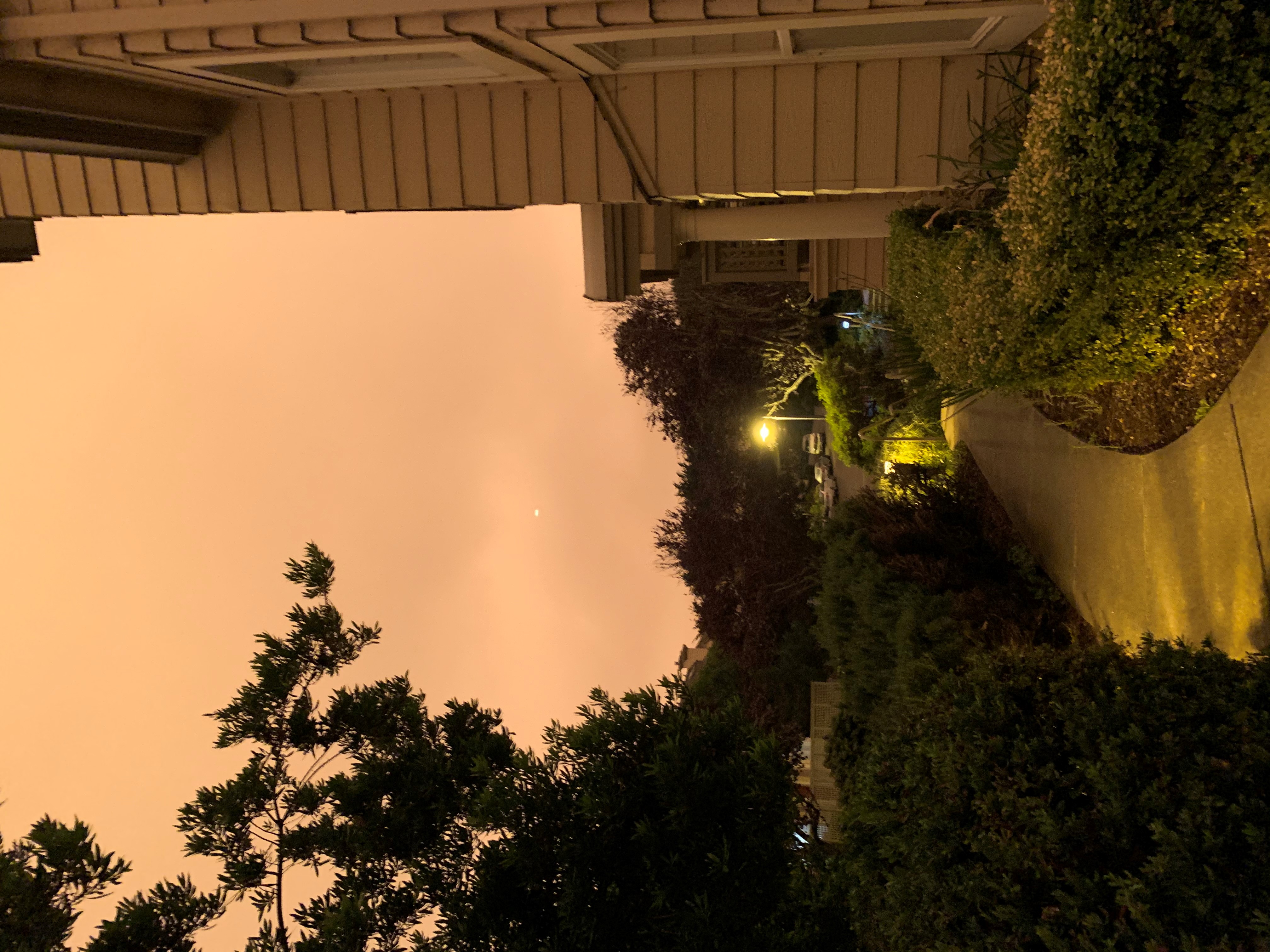
This is the view from Half Moon Bay, Calif., not far from the CZU Lightning Complex Fire, at 9am this morning:

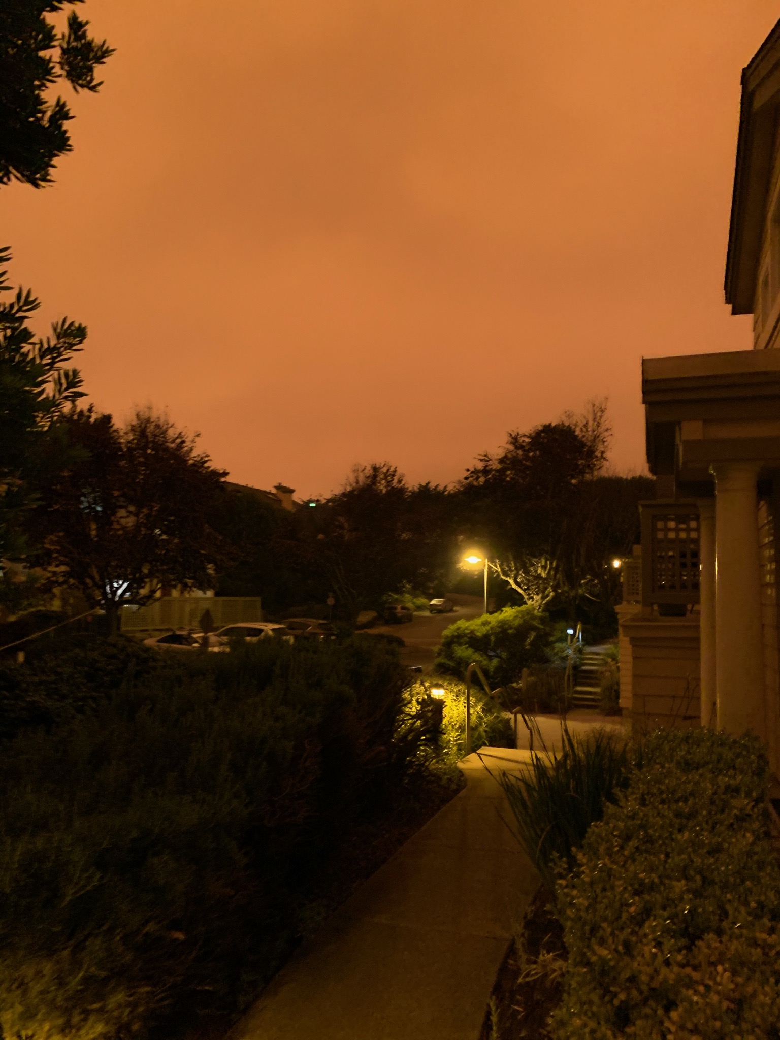
Update: The same reader sent this photo from noon PDT:

Fires continue to burn all over the state despite some modest cooling from this weekend's record temperatures. The California Air Resources Board notes that the increased frequency and severity of these fires, like the increased frequency and severity of other weather-related incidents, comes directly from climate change.

The image seems eerily familiar to us sci-fi fans:

Meanwhile, the Rocky Mountains have a completely different set of weather problems today:

Across parts of the northern and the central Rockies, including Denver, some 6 million people were under winter alerts Tuesday. Across this region, 100 to 200 mm of snow could fall, with locally higher amounts of 300 to 450 mm at the highest elevations through Wednesday. As the day broke, snow was already falling across parts of Idaho, Utah and Wyoming and moving into northern Colorado. By midmorning Tuesday, the snow was expected to spread across Colorado and last through Wednesday morning.

Winter hadn't just arrived through precipitation: Temperatures 17–22°C below average were forecast to lead to numerous records Tuesday and Wednesday.

Lows were forecast to dip below -10°C with wind chills [well below that], with highs that will struggle to get [above freezing] for several locations from the Rockies to parts of the Plains.

On Saturday, [Denver] hit 39°C. Not only was that a daily record high, But it also set an all-time hottest temperature record for the month of September in the city, and it was the furthest into September the city had ever hit 38°C. The previous record was 36.5°C, set last September.

On Monday, Denver hit a high of 34°C, making it the 73rd day in 2020 to exceed 32°C. That tied the all-time record of 73 days set in 2012.

Just 12 hours later, Denver was nearly 34°C colder Tuesday morning, with light snow beginning to fall around the area.

So, in three days, Denver went from a record-shattering 39°C to one of its earliest snowfalls on record.

This year just continues to get weirder.

Record confirmed by the pros

The Chicago Tribune's Frank Wachowski concurs with the Daily Parker: 2020 was the warmest summer in Chicago history:

To be sure, there have been many summers with hotter individual temperatures (2012, 1995, 1988 come to mind) but the warmth this summer has been persistent, especially at night where many warm overnight low temperatures have been observed. 

But when you average out all the high and low temperatures this summer since June 1, the 24.8°C degree average temperature for 2020 just edges out 1955’s record of 24.6°C degrees for top honors. Summer 2020 also finishes 2.7°C degrees above the normal average.  

What’s more, there have been 31 days at or above 32°C at O’Hare this year to date, while the “normal” number of 32°C or higher temps in a year here is just 17, meaning we recorded 182 percent as many over-32°C as normal.  

Today, the first day of meteorological autumn, will be cool and damp, as befits fall.

Oh, and let's not forget, August saw the 8th consecutive month of record-high water levels on Lakes Michigan and Huron:

Calling it: Hottest summer in history

With today's high temperature at O'Hare (29°C) coming in slightly above forecast—as it has almost every day this week—I can now state with confidence that 2020's was the hottest summer ever in Chicago. By my figures, we hit an average daily temperature of 24.8°C, 0.2°C above the record set in 1955.

The string of 6 days above 32°C from the 23rd to the 28th put us over the top, so that even the weekend's milder temperatures couldn't bring us back under the line.

Congratulations?

Oh, and this is the blog's 7,501st post since May 1998. Look for the 8,000th next July.

Happy Monday!

Today is the last day of meteorological summer, and by my math we really have had the warmest summer ever in Chicago. (More on that tomorrow, when it's official.) So I, for one, am happy to see it go.

And yet, so many things of note happened just in the last 24 hours:

Finally, Josh Marshall reminds everyone that Democrats are nervous about the upcoming election because we're Democrats. It's kind of in our blood.

Record looking shaky...

As of Saturday, it looked like we might break the record for hottest summer ever (average daily temperature 24.7°C) in Chicago, set way back in 1955. If the today's forecast holds, however, we will merely tie the record.

This is actually a good-news, bad-news thing. The good news is: (a) we came just a bit short of breaking the record (36.7°C) for August 26th, and (b) a cold front will push through tomorrow evening, dropping temperatures into the high 20s for the weekend.

You know? I'm OK with not breaking the record. It's 33°C at O'Hare and 32°C at my house right now, and that ignores the 21°C dewpoint that makes even light clothes cleve after walking just a few steps outside. And my electric company sent me an email this morning warning I'm about to have a higher-than-expected electric bill.

Roll on October.

On track for Chicago's hottest summer ever

Chicago experienced its hottest summers (June 1st through August 31st) in 1955 (24.7°C), 1995 (24.6°C), and 2012 (24.5°C). As of Thursday, we've had an average temperature of 24.6°C—already tied for 2nd place. If the 10-day forecast holds, we will end the summer a week from Monday with an average temperature of 24.7°C, tying the 1955 record.

WGN-TV's Tom Skilling explains why we have this situation, despite none of the three months of 2020 making it into the top 3. (Hint: all three made it into the top 5.)

How is it possible this summer ranks among the top tier of warmest summers to date here? What about the deadly heat in summer 1995. Or how about the scorcher of a summer in 1988 with its 47 days with above–32°C and seven days of above–38°C?”

1995’s July heat wave was historic and responsible for the greatest loss of life on the books produced by a natural disaster in the Chicago area–but it occupied a week’s time. It was a single hot period and not reflective of the average temp over the full season through August 19 which came in under this years 24.6°C average to date.

It’s true summer 1988 produced the greatest number of above–32°C and above–38°C of any warm season since official records began in 1871. But summer 1988 produced also produced historic drought. Moisture was so limited in the Summer of ’88 that the drier than normal atmosphere allowed nights which cooled more than usual from the broiling daytime highs. So when the comparatively “cool” nights were averaged with the hot daytime highs, the average summer temps through August 19 came in well below this year’s 24.6°C to date.

So, Chicagoans, neither you nor your air conditioning is wrong. This summer has suuuuuuuucked.

Also, starting in January, we will have new climate normals. Every 10 years climatologists crunch the previous 30 years of data and produce a new set. The 1991-2020 set will almost certainly have higher temperatures and precipitation amounts for most US locations than any previous set, just as the 1981-2010 set did. Early in 2020, meteorologist Becky Bolinger ran 29 years of data and discovered that only one county in Iowa had fewer above-average monthly temperatures than below-average from 1991 onward. Every other part of the US experienced rising average temperatures.

In other words: welcome to the new normal, thanks to human-caused climate change.