Just 120 hours ago, a polar vortex wandered into the center of North America and froze us solid. Less than an hour ago, at 8:39am CST, the official temperature at O'Hare hit 0°C—27°C warmer than 9am Monday morning. It's also the first time the temperature has gotten up to freezing since December 29th.
I've lived in Chicago for a long time, so I can say this graph is extraordinary (data from my demo at Weather Now:
Of course, with 250 mm of heavy, wet snow on the ground, rain in the forecast, and temperatures rising to 4°C today, we have new problems:
Patchy drizzle is to fall from the saturated atmosphere into a sub-freezing air mass Friday morning and early afternoon. This could produce slippery spots. But, the main event—a round of rain, likely to be heavy at times—arrives later Friday and continues into Friday night.
With the ground snow-covered and the soil below it frozen, the prospect of rain falling on a 250 mm snowpack at the same time temps surge above freezing is ominous. Moisture has nowhere to go in such a situation but to sit in pools or exit the area as run-off, a development which could produce some flooding.
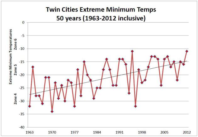
But we're still glad to be shot of those incredibly cold temperatures. We've had 12 days below -18°C this year, a feat achieved in only three other winters since we started keeping score in 1871. Which brings up an interesting graph from Minnesota:

So even this year's bitter cold temperatures in the Midwest fit into a trend showing gradual moderating of Minneapolis weather. I would wager we could produce a similar chart for Chicago. Our -27°C reading Tuesday morning, after all, was still warmer than the record -33°C temperature I experienced (briefly) on 20 January 1985.
Wow did it seem warm this morning. I hope this week was the last of our super-frigid temperatures. Now we've just got to get through a few more months of snow.
Others have commented
The Daily Parker
Polar vortex update Polar vortex update
Copyright ©2026 Inner Drive Technology. Privacy. Donate!