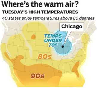
 A "cutoff low" parked over southern Lake Michigan Saturday night, giving Chicago unseasonably cool temperatures and non-stop rain for days:
Precipitation within the storm has been "convective" at times--in other words, it's been the product of towering cumulus clouds. The overcast breaks at times in such an environment as air sinks on the periphery of such showers and this permits spells of passing sun. Veteran observer Frank Wachowski reports 48 minutes of sunlight occurred in Chicago Tuesday and the appearance of sun amid the showers has led to a flurry of stunning rainbow sightings in recent days.
The preponderance of cloudiness has taken a toll on Chicago area temperatures. September 2011 ranks the area's coolest in 10 years. The failure of daytime highs at O'Hare the past six days to reach 18°C makes the period the first since observations began there in 1959 to produce so many sub-18°C days in September.
The ejection of the stubborn upper air low is finally in sight. A southward plunge of chilly, early-season arctic air is forcing jet stream winds to buckle southward out of Canada the next few days. The powerful steering winds will finally "pick the closed system up" and lift it out of the Midwest Wednesday night.
Oh, goody. The rain will go away over the weekend, replaced by early-November temperatures hovering around 10°C. (I like cool weather. Most of my readers do not. Oh well.)
The Weather Channel posted a NOAA video showing the low forming, and then stalling, right on top of us.