Finally. In Chicago, anyway. The farther north you go, the more likely your latest sunset is...earlier.
I explained why this happens December 8th a few years ago. And yet, I feel the need to comment on it yet again...
Chicago might get measurable snowfall tonight, which would be the fourth-latest first fall in history and the first since April 18th:
Though flurries have been observed within the city limits four times this month and seven times since the snow season began this year on Nov. 9, the only "measurable snow" which has fallen has been across the northern suburbs.
That may change as a light-snow-generating disturbance swings across the metro area Thursday night. The system's approach will become more and more evident Thursday as sunshine is filtered by an influx of clouds out ahead of the disturbance's light snow, particularly Thursday afternoon and evening.
But:
If there's a snowstorm in Chicago's future the next two weeks, there is NO computer model consensus on it at this point. That can change fairly quickly this time of year. But for now, Thursday night's wave of light snowfall is the only definitive snow threat the metro area faces in the short term.
I had planned to visit the Tokyo National Museum today, and possibly one of the other museums at Ueno Park, but then this happened:

Yes, a sunny autumn day with the temperature passing 21°C simply did not allow me to go inside. I spent a few hours just walking around Ueno-Koen, encountering the local fauna:
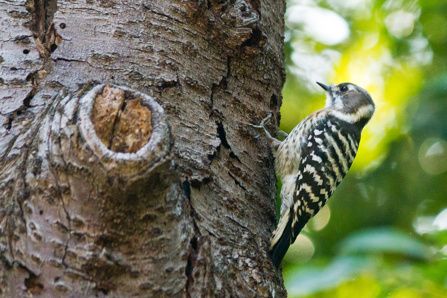
More fauna:

Oh, and hey, my camera shoots video:
(Apologies for the jerkiness; I was hand-holding a 250mm lens.)
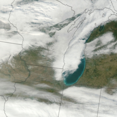 Via the Chicago Tribune, NASA launched a new weather satellite in October that provides incredible high-resolution images of the planet:
VIIRS will collect radiometric imagery in visible and infrared wavelengths of the Earth's land, atmosphere, and oceans. By far the largest instrument onboard NPP, VIIRS weighs about 556 pounds (252 kilograms). Its data, collected from 22 channels across the electromagnetic spectrum, will be used to observe the Earth's surface including fires, ice, ocean color, vegetation, clouds, and land and sea surface temperatures.
During NPP's five-year life, the mission will extend more than 30 key long-term datasets that include measurements of the atmosphere, land and oceans. NASA has been tracking many of these properties for decades. NPP will continue measurements of land surface vegetation, sea surface temperature, and atmospheric ozone that began more than 25 years ago.
NASA has more information about the satellite mission and a gorgeous photo (8MB jpeg) of the East Coast.
My weather demo, Weather Now, is 13 years old today. I launched it as an ASP 2.0 application on 11 November 1998.
The Wayback Machine first crawled the site about a year later, on 20 September 2000. Check out the site's evolution; it's trippy.
The temperature finally got down to freezing at O'Hare, which is the latest freeze recorded there since records started in 1958:
With widespread freezing temperatures across the Chicago metro area, Friday's official low temperature reading at the O'Hare observation site should bottom out well below 0°C --- marking the first time readings there have dropped below that mark since April 1st. It also marks the latest in the season the first 0°C temperature has been observed at that site since it was established in 1959.
(Tom Skilling errs in two places here. First, the O'Hare site opened on 1 November 1958; second, while he's correct that the temperature last dropped below 0°C on April 1st, it only reached 0°C last night.)
The forecast calls for temperatures as high as 16°C this weekend, followed by...winter.
- Two of my Duke classmates;
- Crystal Bowersox;
- Snow (which, in the last five minutes, has disappeared in favor of crystal clear blue skies); and
- An aggressive batch of chicken soup that, about an hour and a half ago, destroyed my laptop.
Three out of four is, all things considered, a good average.
If you're in Chicago, wear layers:
The latest fall storm's "warm sector"—a prod of mild air which floods up the east side of many storms, often fueling t-storms while wrapping moisture into such systems' backside snows—is to send a brief but noticeable surge of warm into at least a portion of the metro area—primarily from the city and south suburban locations Wednesday morning. Some 16°C temperatures are possible before winds shift west and strengthen, sending temperatures diving the remainder of Wednesday into Thursday.
If the scenario unfolds as currently predicted, falling temperatures will take readings from 14.5°C lower by mid and late afternoon, situating readings near freezing at a number of locations before sunset. These would be the coldest daytime readings since April.
Check out the Tribune's graphic. Tomorrow I'll publish the actual temperatures to see how close they were.
For those keeping score, the last freezing temperature we had in Chicago occurred April 21st, but the last below-freezing reading was back on April 1st.
No, not my student loan; my horological one. I might be alone here, but the return of standard time means I get the hour back that I loaned out in March. It also means I don't have to wake up before dawn any more—at least for a couple of weeks. Even Parker seems to like the "fall back." At least, he had the decency not to wake me up until 7:30am.
For most of the U.S. and Canada, today's was the earliest sunrise until February 28th. Unfortunately, today's sunset will the earliest since January 10th, as we enter the 12 or so weeks of afternoon gloom.
On the third hand (I missed my calling as an economist), Chicago's weather today is crisp and sunny, and Parker needs some walks.
Apparently the aurora borealis came all the way down to the middle of the U.S. earlier this week. With a little probing, I found the University of Alaska aurora forecast page. Tonight, we probably won't see the aurorae in Chicago. But there's a huge sunspot right now, so possibly we'll see one later in the week.
Here's the self-updating NOAA map. The bright area shows the current aurora; the red line points to the sun.
