Downtown Chicago got the merest whisper of snowfall last night; O'Hare, our official station, got enough to set two records—in the negative.
Just 200 km away, however, people got a little more than we did:
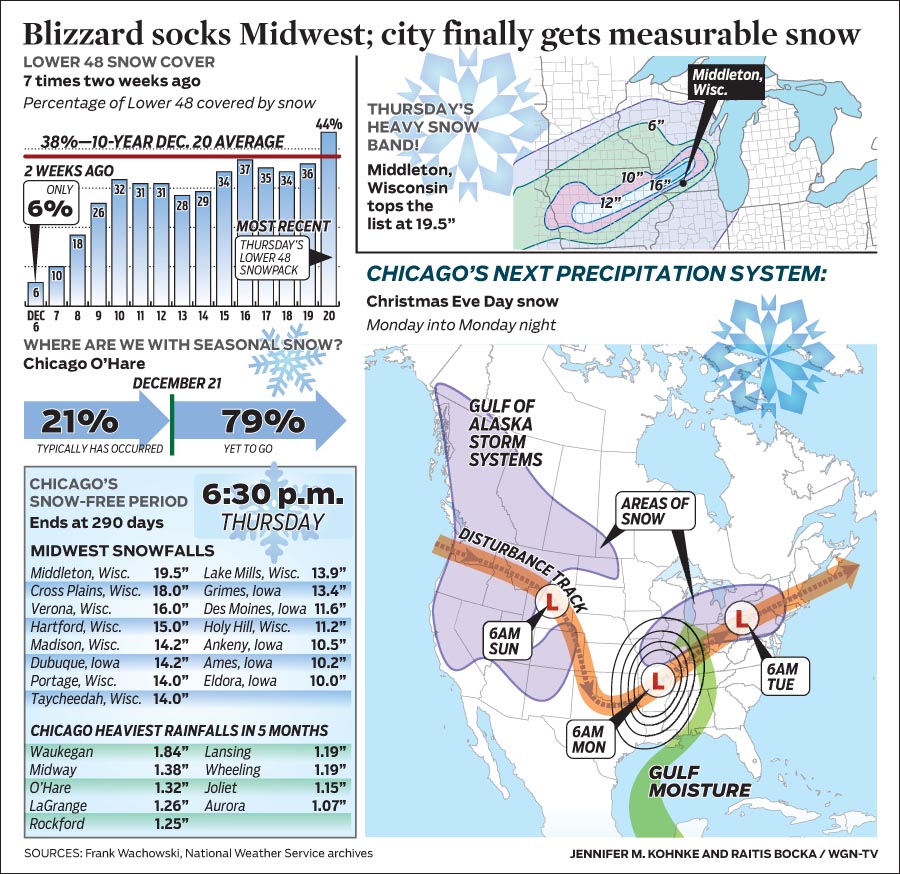
The Madison, WI area was at the epicenter of this storm’s heaviest snows. Snowfalls as of 10:30PM Thursday included: 300 mm at Lena in western Stephenson Co, IL and up to 300 mm or more across Jo Davies County in far northwest Illinois where 33 km of US 20 were closed from Galena to Elizabeth due to snow and blowing snow.
Those wondering where the big snows occurred must check out these eye-catching snow tallies out of areas farther north and west Thursday including 495 mm at Middleton, WI—just west of Madison. Other totals included: Cross Plains WI 460 mm; Verona WI 400 mm; Hartford WI 380 mm; Madison WI & Dubuque, IA 360 mm; Portage and Taycheedah WI 355 mm; Grimes IA 341 mm; Des Moines 295 mm; Ankeny IA 267 mm, Ames IA 260 mm and Eldora IA 254 mm.
In Lincoln Park, I didn't get a chance to brush the one snowflake off Parker's fur that I saw because it melted right away.
I'm in no hurry for snow, though. No, I am not.
Chicago has officially gotten measurable snowfall in the past couple of hours, ending the longest snow-free period in history. In the 291 days since March 4th, we haven't gotten more than a few flakes, less than the threshold 2.5 mm required to count as "measurable." The previous record, 280 days, was set in 1994.
This is also the latest day for our first snowfall; the previous record was set on 16 December 1965. (With only ten hours left until the solstice, you think it could have waited?)
Like so much of Chicago's weather, of course, when it changed today, it really changed:
The heaviest snow was expected to fall from 5 p.m. to 9 p.m. with wind gusts of 80 to 95 km/h. Seventy-five to 175 mm is expected in the far northwest suburbs, 50 to 100 mm in Chicago and 25 to 75 mm in the south and southwest suburbs.
The weather service says the winds will be the real problem. "We may not get a whole lot of snow but the potential for snowing, drifting and poor visibility is very high," weather service meteorologist Mark Ratzer said.
In its storm warning, the weather service said the greatest chance of near white-out conditions is near the shoreline in Lake and Porter counties in Indiana. The storm warning is in effect from 3 p.m. until 3 a.m. Friday.
In western Illinois and Wisconsin, a blizzard warning is in effect with as much as a foot of snow forecast. Snow could fall 25 to 50 mm an hour around Rockford late in the afternoon, the weather service said.
But this is Illinois. We can handle it: "IDOT was mobilizing more than 550 snow plows responsible for roads in northern Illinois while the Illinois Tollway was preparing its full fleet of 182 snow plows to try and clear the 286-mile network of toll roads in 12 counties in northern Illinois." I believe that number represents more snow plows than exist in the United Kingdom, but I could be wrong.
As I've noted before, only one Web application still lives in my living room the Inner Drive Technology Worldwide Data Center: Weather Now. In the last few days, it's showing one more good reason that it needs to get to Windows Azure pronto.
Take a look at my Google Analytics view of incoming visitors:
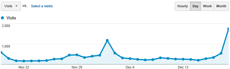
What is going on? How do I go from 300 daily unique visitors to 1,800 in two days? Take a look at where they're coming from:
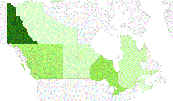
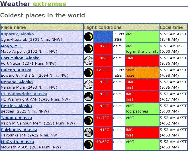
Yes, that's right. Close to 40% of Weather Now's traffic came from the Yukon Territory yesterday. And another 40% came from Alaska. And they're all going to this page for some reason. This might be why:
So how does Azure enter into it? Simply, if you have a Web application running on your own server, and you get a 750% increase in traffic, your server may not be able to handle it. Or, worse in a way, you might have been running the server capable of handling the peak load all the time, at great expense in electricity and hardware.
With Azure, you can simply bring another instance online, or increase the size of your running instance, or do any number of things to adapt quickly to the increased load, without having to buy or move the hardware. Then, when the load returns to normal, you can spin down the idle capacity. The trick is, you only pay for the capacity you're actually using.
I'm getting a lot closer to moving Weather Now, but a deadline looming at my paying job tomorrow has my attention at the moment. So more on this stuff later. Meanwhile, if you're in the Yukon or in central Alaska, stay warm, folks!
Coincident with last week's release of Chasing Ice, a documentary about how climate change is affecting the polar regions, this month's Scientific American looks at how sea ice loss causes extreme weather.
In the article—unfortunately behind a tall paywall—Charles Greene demonstrates how the loss of Arctic sea ice allows large loops in the mid-latitude jet stream to form, and to persist. Last winter, a negative Arctic oscillation combined with a positive North Atlantic oscillation (which controls weather in Europe) to keep most of the U.S. warm and most of Europe cold.
(If I can figure out how to connect my print subscription to their digital offer, I'll quote more extensively.)
Chicago has had no measurable snowfall since March 4th, 281 days ago, which is the longest such period in Chicago history:
If no measurable snow falls at O'Hare today [it didn't—DB], we could go on to shatter the previous record by at least another 4 days. The forecast is dry after today through the end of the week. The graphics [on WGN's blog post] show the total snowfall accumulation forecast for the next 10 days ending early next Thursday morning. The GFS model (on top) shows a potential of 33 mm during the period while the European model (on bottom) shows a potential for up to 102 mm. Hang in there snow lovers!
A snow-free environment from March 4th to December 14th is more normal for Raleigh, N.C., not for Chicago. Or anyway, it used to be.
Chicago's official weather station lived at Midway Airport from 1928 until 1958, when it moved up to O'Hare. As I mentioned yesterday, Chicago's record high temperature for December 3rd is 22°C. Yesterday's official temperature only got up to 21°C, so we didn't break the official record.
A funny thing happened, however. Yesterday's temperature broke Midway's record, tying the official record set at O'Hare in 1970:
The level of warmth observed across the Chicago area Monday ranked among the rarest of the rare in December. Temperatures at 21°C and higher are exceedingly rare in December---it's happened only twice before on Dec. 3, 1970 (21.6°C) and Dec. 2, 1982 (same).
Further underscoring the rarity of such unseasonable warmth is the fact that of the possible 4,405 December days that are part of the city’s 142 year observational record, there have now been just 3 days on the books with temperatures at or above 21°C!
Chicago’s temperature reached the 21°C mark at 2:14 pm at Midway Airport and at 2:44 pm at O’Hare.
Midway’s peak reading was to end up reaching 22°C, blowing past all of the South Side site’s previous highest December temperatures to become the month’s warmest on record since observations began there in 1928.
Put another way, that temperature is normal for September 22nd and May 23rd in Chicago, or December 3rd in Tampa, Fla.
Today the weather has felt more like the beginning of November or the first week of April: closer to normal, I suppose, but still remarkably warm for December.
Yesterday it was 17°C; today, so far, it's 19°C. (The record temperature for December 3rd is 22°C, set in 1970.)
But no, there's no global warming.
Geologist James Powell points out that the peer-review process keeps finding in favor of climate change:
.png)
The most obvious criticsism—that this is an argumentum ad populum—only works if you misunderstand how science works. Every scientist has an implicit incentive to prove some other scientist wrong. You can make your career in science by showing that the received wisdom doesn't fit all the evidence. So the numbers in that pie chart have to raise eyebrows, even if the eyes under them have blinders on.
Since the planet has been hotter in the past, I don't worry that global climate change will kill everyone. In fact, Chicago will probably do fine, as will the Canadian plains and much of central Asia.
The problem with the American right wing, not to mention other governments worldwide, is that by refusing to believe the climate is changing—regardless of the cause—they're refusing to take simple actions against the predictable consequences of it. Ostriches don't stick their heads in the sand in real life, because if they were to do that, they'd be killed by the things they were hiding from. Of all earth's species, only humans can look at impending doom and ignore it. Or, to put it another way:
No, I don't mean "will we have to endure another six weeks of an election." I mean that Chicago today hit 17°C, not a record (22°C in 1982), but also more normal for mid-October than for the second day of meteorological winter.
Tomorrow may be warmer. The Climate Prediction Center forecasts a warm December followed by more normal temperatures through March, so we might get a good Chicago winter anyway.
Remember, though, that warm winters lead to warm summers (though not necessarily the reverse), so I sincerely hope it cools off a bit before April. I'll take a couple of frigidly-cold months in exchange for a cool summer.
Via Sullivan, a new variety of bear has appeared in Canada because of climate change:
One such sign [of environmental pressure on bears] is the emergence of a new creature in the polar bear’s range, first spotted in the wild in 2006 near Sachs Harbour, Northwest Territories. It’s got a long neck like a polar bear, but it’s smaller. It lies and behaves like a polar bear, but it has shoulder humps. The new creature has hairy paw soles like a polar bear, but its hair is mostly solid, with only patches of hollow hair.
As caribou migration routes have moved North, grizzlies have followed and started mating with polar bears. Not only have they produced hybrid young, but those young are fertile. Polar bears and grizzlies only diverged about 150,000 years ago and haven’t developed many genetic differences, despite quite dramatic visual dissimilarities. Second-generation hybrids have now been confirmed in the wild.
This kind of thing isn't new, but we don't often see it with large predators. On the other hand, about 30,000 years ago, another large predator moved into a cousin species' territory as the earth warmed up, and interbred, and went on to invent blogs.