It happens every year, and every year it surprises me: from mid-August to mid-October, the days get shorter quickly. Three weeks ago I was waking up to daylight; this morning, I realized I was waking up to twilight. In three weeks it'll be dark at that hour. Right now, every day, the sun rises a minute later an sets a minute earlier.
Nothing profound or particularly surprising here. Just an observation.
The National Oceanic and Atmospheric Administration reported yesterday that 2011 was hot, damn hot, real hot:
The average U.S. temperature in August was 24.3°C, which is 1.7°C above the long-term (1901-2000) average, while the summertime temperature was 23.6°C, which is 1.3°C above average. The warmest August on record for the contiguous United States was 24.3°C in 1983, while its warmest summer on record at 23.7°C occurred in 1936. Precipitation across the nation during August averaged 58.7 mm, 7.4 mm inches below the long-term average. The nationwide summer precipitation was 25.4 mm below average.
Climate highlights include:
- Excessive heat in six states – Arizona, Colorado, New Mexico, Texas, Oklahoma, and Louisiana – resulted in their warmest August on record. This year ranked in the top ten warmest August for five other states: Florida (3rd), Georgia (4th), Utah (5th), Wyoming (8th), and South Carolina (9th).The Southwest and South also had their warmest August on record.
- Several major U.S. cities broke all-time monthly rainfall amounts during August. New York City (Central Park) measured 481.3 mm of rain, exceeding the previous record of 428 mm in 1882. In Philadelphia, 490.5 mm of rain was observed, besting the previous monthly record of 332 mm in September 1999.
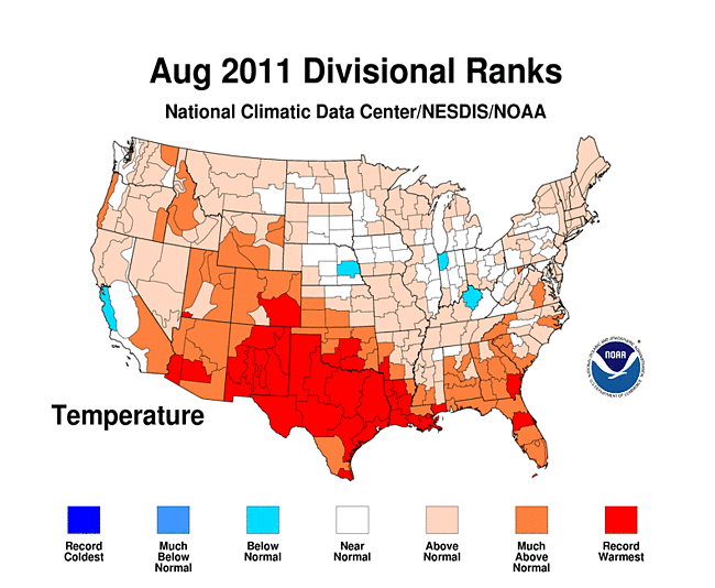
So, weather extremes, a hot summer, record rainfall, and massive property damage from storms. Can't wait to see what happens this winter.
The Economist Gulliver blog makes a good case that media coverage of Irene was appropriate for the threat:
Hurricanes are serious business. They have the capacity to cause billions of dollars in damage and kill hundreds or thousands of people. They have political consequences, too—no politician wants to be blamed for a disaster the way President George W. Bush was after Hurricane Katrina. Moreover, it is very unusual for a hurricane to hit America's north-east, where around one sixth of Americans live and a quarter of the country's economic output is produced. An unusual, potentially disastrous event that was certain to affect millions of Americans and put billions of dollars of property at risk is just the sort of thing the media should be covering. Just because Irene wasn't the disaster that some Americans feared doesn't mean it wasn't important to cover it.
Another way to look at it, just because Irene didn't cause more damage doesn't mean the preparations and coverage were wrong. Just two days ago it looked like Manhattan, Queens, Nassau, Suffolk, Hoboken, and Jersey City—places where millions of people live just a few meters above sea level—could experience devastating damage from a storm surge. This is, remember, the first hurricane to hit New York City in about a century.
I'm very happy the storm did as little damage as it did. And even though it turned out to be unnecessary, I'm glad Mayor Bloomberg and Governors Cuomo and Christie took the actions they did to prepare for what looked like, earlier this weekend, an unprecedented disaster.
Breaking news:
Nearly 300,000 New York City residents were told Friday to get out of their homes in a first-ever mandatory evacuation as officials ordered an unprecedented shutdown of the city’s mass transit system for Saturday in advance of Hurricane Irene, raising the prospect of a singular scramble as hundreds of thousands of residents try to get out of the massive storm’s way.
Mayor Michael Bloomberg ordered an evacuation by 5 p.m. Saturday for low-lying areas that house about 270,000 people. Meanwhile, Gov. Andrew M. Cuomo said subways, buses and commuter trains in the city, on Long Island and in the northern suburbs will begin their final runs around noon Saturday.
Officials earlier ordered Fire Island evacuated, starting half an hour ago.
Hurricane Irene, currently category 2 on the Staffir-Simpson scale, looks like it's heading straight for New York City. Both the NYC and New Jersey emergency management agencies have published maps (pdf) showing the likely flood zones for various categories of hurricanes. They're scary.
I used to live in Brooklyn Heights, N.Y., and Hoboken, N.J. Both areas would be affected by a category 1 hurricane. My place in Hoboken, in fact, was only 2 m above sea level. My stuff would probably be OK—I lived on the fourth and fifth floors—but a moderate storm surge would likely flood the entire city of Hoboken, and make it impossible to live there for weeks.
I hope all my friends in the New York Metro are taking reasonable steps to protect themselves and whatever stuff they can get out. It's going to be a wet weekend in the Northeast...
Update, 13:27 CDT: New York City and the surrounding area have decided to shut down all commuter train, subway, and Amtrak service in the region starting at noon tomorrow.
We're still three weeks from meterological autumn and we've already had the wettest summer in 54 years and the second-wettest ever:
The new rains are to fall in the midst of the Chicago area's wettest meteorological summer (the period which began June 1) in 54 years. A total of 420 mm has occurred to date which makes this the second wettest summer to date since the official observational record began here in 1871. That amount is nearly twice the 140 year average to date of 219 mm.
And what do we have in today's forecast? Yup. Rain.
At least it's only getting up to 26°C this weekend. I have my windows open for only the second time since July 7th.
Last night, after getting back from San Antonio, I opened the windows for the first time in nearly six weeks. We had, I believe, one of the hottest and stickiest Julys I've ever experienced. But yesterday when I got home the temperature was 23°C and dropping—finally cooler outside my air-conditioned apartment than inside it.
Unfortunately for my colleagues down in Texas, it's no cooler there:
| Day | San Antonio | Chicago |
|---|
| Sun Aug 7 | 38°C | 30°C |
| Mon Aug 8 | 38°C | 27°C |
| Tue Aug 9 |
39°C | 27°C |
| Wed Aug 10 | 39°C | 25°C |
| Thu Aug 11* | 40°C | 24°C |
* forecast
I understand, however, that they have beautiful winters....
Six months ago, at North Avenue Beach in Chicago:
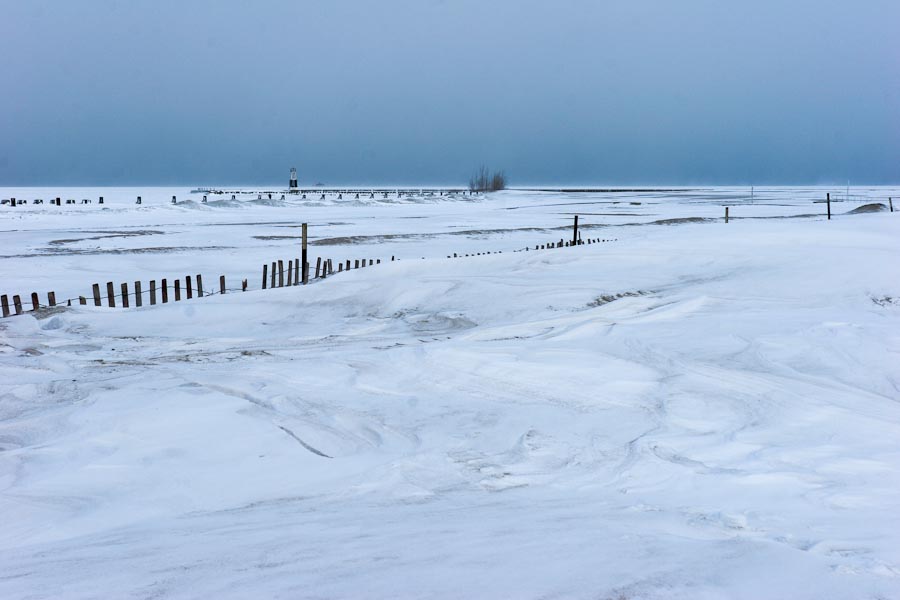
2 February 2011, Canon 20D at ISO-100, 1/250 at f/11, 27mm, near here.
I should have posted this photo a couple of days ago, when Chicago baked in near-40°C heat. Today's forecast calls for a mostly-pleasant 27°C under sunny skies.
Go back and relive those few days last February when it gets hot again.
The Tribune today has this graph showing the extreme precipitation we've had this year:
.jpg)
So far in 2011, Chicago has not only experienced its wettest year ever, but we've almost reached our annual normal rainfall total:
With the record (283 mm) July rains adding on to already above-normal precipitation prior to this month, Chicago's official total for 2011 has reached 858 mm - or 351 mm above normal at this point in the season. Chicago's official rain gage at the O'Hare International Airport observing site has now registered 93 percent of the normal annual 921 mm.
Today, however, it's sunny and clear, and not quite as hot as it has been recently.