Just a pre-weekend rundown of stuff you might want to read:
- The US Supreme Court's investigation into the leak of Justice Samuel Alito's (R) Dobbs opinion failed to identify Ginny Thomas as the source. Since the Marshal of the Court only investigated employees, and not the Justices themselves, one somehow does not feel that the matter is settled.
- Paul Krugman advises sane people not to give in to threats about the debt ceiling. I would like to see the President just ignore it on the grounds that Article 1, Section 8, Article VI, and the 14th Amendment make the debt ceiling unconstitutional in the first place.
- In other idiotic Republican economics (redundant, I know), Rep. Buddy Carter (R-GA) has proposed a 30% national sales tax to replace all income and capital-gains taxes that I really hope the House passes just so the Senate can laugh at it while campaigning against it.
- Amazon has decided to terminate its Smile program, the performative-charity program that (as just one example) helped the Apollo Chorus raise almost $100 of its $250,000 budget last year. Whatever will we do to make up the shortfall?
- How do you know when you're on a stroad? Hint: when you really don't want to be.
- Emma Collins does not like SSRIs.
- New York Times science writer Matt Richtel would like people to stop calling every little snowfall a "bomb cyclone." So would I.
- Slack's former Chief Purple People Eater Officer Nadia Rawlinson ponders the massive tech layoffs this week. (Fun fact: the companies with the most layoffs made hundreds of billions in profits last year even as market capitalization declined! I wonder what all these layoffs mean to the shareholders? Hmm.)
- Amtrak plans to buy a bunch of new rail cars to replace the 40-year-old rolling stock on their long-distance routes. Lots of "ifs" in there, though. I still hope that, before I die of old age, the US will have a rail travel that rivals anything Europe had in 1999.
- The guy who went to jail over his fraudulent and incompetent planning of the Fyre Festival a couple of years ago wants to try again, now that he's out.
Finally, Monica Lewinsky ruminates on the 25 years since her name popped up on a news alert outing her relationship with President Clinton. One thing she realized:
The Tonight Show With Jay Leno died in 2014. For me, not a day too soon. At the end of Leno’s run, the Center for Media and Public Affairs at George Mason University analyzed the 44,000 jokes he told over the course of his time at the helm. While President Clinton was his top target, I was the only one in the top 10 who had not specifically chosen to be a public person.
If you don't follow her on social media, you're missing out. She's smart, literate, and consistently funny.
With 10 days to go to solidify the record, Chicago has tied for cloudiest January in history, with 20% of possible sunshine (normal is 40%), with 11 of the first 19 days of 2023 giving us exactly zero sun. The record, set in 1998, is 20 of 31 days without sun, and three recent Januaries (2017, 2020, and 2021) saw no sun on 16 of 31 days.
The cause, though, is reflected in us seeing the second-warmest January since records began in 1871, with every single day having an above-normal temperature.
The culprit? A persistent La Niña system in the south Pacific combined with global warming, as WGN-TV meteorologist Tom Skilling explains:
You know, this is a La Niña winter and we’ve done some in-house work on these. Since 1950, La Nina winters have been very volatile in this area. You move from arctic air masses one week to unseasonably mild air the next. We had that cold blast that hit around Christmas week. Now, we’re in the 22nd consecutive day of above normal temperatures. This already is the second-warmest January on the books here — at least so far it is. You have to go back to 1850 to find a January 1-17 period that’s warmer than what we’ve seen this year.
January is typically our coldest and one of our snowiest months and home to some of our blockbuster historic snowstorms, not the least of which is the benchmark blizzard of 1967 that shut the city down.
In Chicago, the winters of the 1970s were collectively our coldest and snowiest on record — and we have records that go back to 1871 and the Great Chicago Fire.
The coldest temperatures occurred in the 1980s. We had back-to-back 26 below zero temperatures in January 1982. And then we had the all-time coldest three years later in 1985 (that was minus 27 degrees).
If you don’t believe climate change is at work, just look at what’s happened to the character of our winters around here. While the decade of the 1970s was the coldest and snowiest on record, we have warmed precipitously since then.
Last time I looked, our winters are running more than 3 degrees on average warmer than the winters of the ’70s, which is a big change. I don’t know if you remember the 1970s, but those winters were barbaric. We’d have these incredible snowstorms and then they’d be followed by these sieges of subzero weather. We don’t get that anymore.
We still have 38 days of winter left, however, and Sunday could see more normal temperatures plus 25 mm or more of snow. And someday, we might even see the sun again.
I just got an alert that the outside temperature at my house went above 10°C:
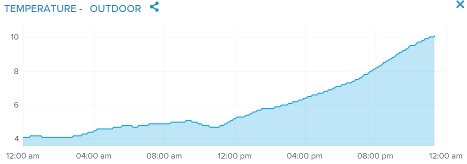
It's mid-January, and my house in Chicago is only 2°C cooler than San Francisco. (O'Hare is only 1°C cooler.)
Maybe I have the wrong attitude. Chicago will likely have its 2nd or 3rd warmest January in history, followed by a warm and lovely spring, with flowers and sunshine for all. So I should just enjoy it. Cassie sure is.
I keep saying that the decently-governed city whose winters have gotten remarkably better in my lifetime next to the largest source of fresh water in the country will, as I've predicted for years, become a pretty good place to live in a 2°C-warmer environment. After all, a 10°C HVAC delta between inside and outside in July is less costly than a 40°C delta in February. (Seriously, if you like the idea of having unlimited fresh water to drink and only a few days a year with weather that can kill you, move to Chicago.)
And yet, I'm solidly Generation X. We learned from a young age that when things seem way better than we expected, they'll average out with a vengeance soon enough.
Sure, Chicago has a better chance of success than any other city its size over the next 100 years. But tens of millions will die worldwide and hundreds of millions will have to move after the first pulse. Then we'll have another pulse. Then a third. When my nephews' grandchildren explore the world, they'll volunteer on farms in Greenland and surf beaches outside Raleigh, and they might be the last people who taste real maple syrup.
If I found a djinn, my first wish might be that people worldwide understand that, if we continue to deny how much we're affecting the world, we'll only have a few places (like Chicago) that people will want to live in. If only that were enough.
Chicago Transit Authority president Dorval Carter, Jr., blamed "extremely higher-than-normal call-offs" (i.e., a blue flu) for the New Year's Eve failures that left The Daily Parker waiting on a platform 35 minutes for the El:
It’s not unusual for CTA workers to “call off” on holidays, but the CTA has in the past been ready to replace them. But this year, with a shortage of train operators in the ranks, the CTA couldn’t deliver the number of free trains it promised.
The CTA promoted increased service on the Blue and Red lines on New Year’s Eve, advertising free train rides sponsored by Miller Lite. Carter did not say how many workers called off, and CTA officials did not provide a number after Friday’s meeting.
CTA worker unions, represented by Local 308 and Local 241, did not immediately respond to requests for comment.
Carter said he would work with the unions and employees to come up with better ways to incentivize staff to come to work. Disciplinary measures could only go so far, considering the worker shortage, he said.
“We are operating very close to the margins,” Carter said. “I am trying to both put out a level of service that is within the constraints of the workforce that I have, but recognizing that in order for that to work, my workforce has to show up.”
One factor possibly limiting the available workforce: wages that have not kept up with inflation. If you want more people to work for you, pay more; QED. But even Chicago, with one of the best transport networks in the world, still struggles to see public transit as a public service rather than a profit-making enterprise. So who should pay more for the CTA? All of us in Chicago, perhaps by taking back some of the Federal money we send to Oklahoma for their useless freeway projects.
At least I didn't get too cold on the Brown Line platform on New Year's Eve. I still would have liked to see my friends earlier than I did.
One Daily Parker reader sent me this clarification that the big hole in CA-92 preventing people in Half Moon Bay, Calif., from reaching Silicon Valley is not, technically, a sink hole:
The first thing to know about that sinkhole that opened on Highway 92 on Thursday: It’s not a sinkhole:
Geologists make a distinction between sinkholes, which require a particular blend of soils — limestone, salts, gypsum and other components — and caverns that appear with water due to engineering failures, aging infrastructure or simply not building enough capacity to handle the kind of runoff experienced in San Mateo County this month. They also note it’s a distinction without a difference for anyone stuck in traffic.
“Even scientists can’t always agree whether we want to call them sinkholes,” said Randy Orndorf, a research geologist for the USGS in Reston, Va., who is known as the sinkhole expert within the service. “I think about 20 years ago when I started doing research, we tried to say these are infrastructure failures and people still wanted to call them sinkholes.”
For the most part, sinkholes are limited to regions of karst terrain, which underpin about 25 percent of the United States land mass. Sinkholes are most common in these areas, where the underlying soil simply dissolves in water. Sinkholes are most common in Florida, Alabama, Missouri, Kentucky, Texas, Tennessee and Pennsylvania, according to the USGS. No one knows how many sinkholes develop in a given year because most likely occur in remote areas.
(The photo caption really summarizes things well: "Geologists say this isn't a sinkhole, but they acknowledge it doesn't really matter what you call it.")
Thanks for filling us in, USGS. (Actually, I love this kind of journalism. What can you say about rain in California? Let's dig into the issue! [Sorry.])
And every time I think about sinking, I sink of this:
Staring out a window at the Terminal A parking garage at DFW Airport, I pause to check my email. Top of the pile I see this lovely report from MSNBC:
Californians should brace for flooding and possible landslides as “heavy to excessive rainfall” is expected over the weekend and into next week, forecasters warned early Saturday.
With recovery efforts continuing in parts of the state which was battered by storms earlier this week, the National Weather Service said in a bulletin that a couple of Pacific storm systems were forecast to impact the West this weekend “bringing heavy lower elevation rain, significant mountain snow, and strong winds.”
The first system would approach the coast Saturday and move inland, the bulletin said, adding that there were “multiple slight risks of excessive rainfall,” that could lead to localized instances of “urban and small stream flooding as well as mudslides.”
What does NWS say about downtown San Francisco?
Tonight
Showers and possibly a thunderstorm before 1am, then rain likely, mainly between 1am and 4am. Some of the storms could produce heavy rain. Low around 9. West wind 14 to 16 km/h, with gusts as high as 32 km/h. Chance of precipitation is 90%. New rainfall amounts between 5 and 7.5 mm possible.
Sunday
Rain, mainly after 10am. High near 12. Southwest wind 11 to 18 km/h. Chance of precipitation is 80%. New precipitation amounts between 2.5 and 5 mm possible.
Sunday Night
Rain. Low around 8. East southeast wind 19 to 29 km/h decreasing to 5 to 15 km/h after midnight. Winds could gust as high as 40 km/h. Chance of precipitation is 100%. New precipitation amounts between 1 and 2 cm possible.
M.L.King Day
Rain, mainly before 10am. High near 12. Breezy, with a west northwest wind 26 to 35 km/h, with gusts as high as 47 km/h. Chance of precipitation is 80%. New precipitation amounts between 1 and 2.5 mm possible.
Monday Night
A 20 percent chance of rain before 10pm. Mostly clear, with a low around 7.
Tuesday
Sunny, with a high near 12.
Lovely. Perhaps I'll get my morning coffee before it starts to rain again tomorrow?
I can't remember ever taking an umbrella to California, but I'm packing one today. So instead of the sunny and cold weather I've usually experienced in San Francisco, the forecast calls for wet and cold weather every day I'm there, with the sun coming out right after I leave.
Here in Chicago, we've had just 20% of possible sun this month, which WGN points out has completely obscured that we have 15 minutes more daylight than we had at the solstice. On the other hand, so far we've had the 4th-warmest January in history, with significantly above-normal temperatures predicted through the end of the month.
At least I'll see the sun on my flight today...
I got a lot done today, mostly a bunch of smaller tasks I put off for a while. I also put off reading all of this, which I will do now while my rice cooks:
- The EU's Copernicus Climate Change Service determined that 2022 was the fifth-hottest year on record, once again making the last 8 years the hottest on record. As North America sees record warmth and record-low snowfall this winter, we can guess how 2023 will end up.
- In no small irony, Illinois was actually cooler than normal last year. I've said before, Chicago will look better and better as the world looks worse and worse.
- Loathsome creep Andrew Tate lost all four of his appeals to Romania's appellate court, so will remain in the country until his trial for human trafficking.
- A report by INRIX Research put London and Chicago at the top of the list of cities with the worst car traffic. Oddly, in a related study, London also ranked 10th and Chicago ranked 20th of cities with the best public transit.
- Delta Airlines' "free" wi-fi reminds passengers of the adage, when someone else pays, you're the product, not the customer.
Finally, I've mentioned heading to San Francisco this coming weekend, has gotten some rain. By "some" I mean over 350 mm of rain in the past 15 days, making it the rainiest two weeks since 1866. The weekend forecast does not look encouraging: rain likely, highs around 12, lows around 9, and yet more rain likely. I have never taken an umbrella to California before. First time for everything, I guess.
And now my rice is done.
For the first week of 2023, Chicago got just 2% of possible sunlight, with no sun at all since last Monday. Normal for January is 40%.
On the other hand, so far it's the 4th-warmest January in history, almost 10°F (6°C) above normal, with the 8-to-14 day forecast predicting much above normal temperatures. Note the top 7 are all in the past 31 years.
Unfortunately those two things correlate strongly. So we probably won't get a lot of sun until it either cools down or warms up. Such is winter in Chicago.
At least we haven't gotten 30 cm of rain, like parts of California...
I took my use-it-or-lose-it floating holiday Friday and today was a company holiday. So it feels like today's really Sunday, but so was yesterday, after two Saturdays in a row.
I think tomorrow's Tuesday but for me it'll be Monday. I think.